|
||

|

|
|

|
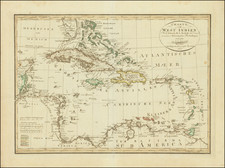
This 1679 map titled The Chief Islands of ye Antille and Lucayes was created by John Seller and published in his Atlas Minimus in London. It provides a focused and informative depiction of the principal islands of the Antilles and the Lucayes (present-day Bahamas), extending from southern Florida down to the northern coast of South America.
In the late 17th century, the Antilles and Lucayes were crucial territories in the burgeoning maritime and colonial ambitions of European powers. Seller's map, in this context, presents a geographical understanding attuned to these global dynamics. It offers a visual document of the islands that played a central role in trade routes, strategic military maneuvers, and colonial expansion, thereby indicating the geopolitical significance of these regions.
"The Chief Islands of ye Antille and Lucayes" represents a particular era of geographical exploration and colonial ambition. As such, it remains an insightful historical document that encapsulates the late 17th-century understanding of these crucial Caribbean territories. Notably, Seller's map provides a clear and comprehensive guide to the geography of these islands, a testament to the advanced cartographic practices of its time.
John Seller was one of the most notable map and instrument makers in England in the late-seventeenth century. He was especially known for the sea charts, many of which featured in his influential English Pilot and Atlas Maritimus. Seller was born in London in 1632. His father was a cordwainer and John was apprenticed to Edward Lowe, of the Merchant Taylors’ Company. He was made free of that company in 1654. Later, he also was made a brother of the Clockmakers’ Company, which housed several instrument makers. He started business as a compass maker but expanded his offering to include navigational instruments and charts.
Seller’s career was halted temporarily, and fantastically, when he was tried for high treason in 1662. He was accused of involvement in a plot led by Thomas Tonge. While Seller likely only unwisely repeated rumors, he was convicted. The other conspirators, who did admit some degree of guilt, were executed, but Seller maintained his innocence and, via insistent petitions, he eventually secured his release from Newgate Prison.
This episode did not seem to slow Seller’s rise too much, however. Seller was granted a royal license to publish English-language maritime atlases. This gave him a near-monopoly and led to his being named hydrographer to the King in 1671. Although the point of the project was to produce English charts of Dutch dominance and bias, Seller ended up using many Dutch plates as his base material. The first volume of The English Pilot was published in 1671, followed by more volumes as well as The Coating Pilot (1672) and the Atlas Maritimus (1675). Seller was commercially successful, but some of his projects required further support. The English Pilot was eventually taken over by John Thornton and William Fisher, for example, and his proposed English atlas only produced maps of six counties.
Seller’s sons, John and Jeremiah, followed in their father’s profession. Seller also apprenticed several promising young men, including Charles Price, with whom his sons partnered. Through Price, Seller can be seen as the founding figure of an important group of London mapmakers that included Price, John Senex, Emanuel Bowen, Thomas Kitchin, and Thomas Jefferys.
![Grand Bay of Nipe on the North side of Cuba from Spanish Draughts [on sheet with:] Plan of Puerto de Baracoa](https://storage.googleapis.com/raremaps/img/small/89453.jpg)
![[Saint-Marc, Haiti] Plan de la Ville de St. Marc, dans l'Isle St. Domingue . . . 1785](https://storage.googleapis.com/raremaps/img/small/88259.jpg)