


|
||

|

|
|

|
"Mexico or New Spain," a map created by John Seller and first issued in London around 1676, presents an overview of the expansive Spanish Empire in America. The map's intriguing westward orientation and inclusion of regions ranging from the Caribbean to South America to Virginia reflect a characteristic broad perspective of geographical representation from the late 17th century.
The map forms part of Seller's innovative series of playing cards, a medium that merged entertainment with geographical education. Notably, the depiction of the Spanish Empire does not appear to be derived directly from any existing map of the time but rather offers a generalized representation customary to the era. Its scope stretches northwards along the eastern coast to include the English colony of Virginia, while also highlighting various features of the south and southwest.
The historical context in which this map was created saw England increasingly invested in overseas exploration and colonization. Seller's cartographic work, therefore, can be appreciated as a reflection of these expanding global interests and the consequent need for accessible geographical information. The map's reach into the Spanish Empire, including the newly designated "New Spain," signifies the geopolitical undercurrents of the period.
"Mexico or New Spain" is known to exist in two states, with the second appearing in the Book of Geography. An intriguing detail of the map is an engraved list of divisions of "The Kingdom of Mexico Now called New Spain," offering a structured interpretation of Spanish colonial territories.
John Seller was one of the most notable map and instrument makers in England in the late-seventeenth century. He was especially known for the sea charts, many of which featured in his influential English Pilot and Atlas Maritimus. Seller was born in London in 1632. His father was a cordwainer and John was apprenticed to Edward Lowe, of the Merchant Taylors’ Company. He was made free of that company in 1654. Later, he also was made a brother of the Clockmakers’ Company, which housed several instrument makers. He started business as a compass maker but expanded his offering to include navigational instruments and charts.
Seller’s career was halted temporarily, and fantastically, when he was tried for high treason in 1662. He was accused of involvement in a plot led by Thomas Tonge. While Seller likely only unwisely repeated rumors, he was convicted. The other conspirators, who did admit some degree of guilt, were executed, but Seller maintained his innocence and, via insistent petitions, he eventually secured his release from Newgate Prison.
This episode did not seem to slow Seller’s rise too much, however. Seller was granted a royal license to publish English-language maritime atlases. This gave him a near-monopoly and led to his being named hydrographer to the King in 1671. Although the point of the project was to produce English charts of Dutch dominance and bias, Seller ended up using many Dutch plates as his base material. The first volume of The English Pilot was published in 1671, followed by more volumes as well as The Coating Pilot (1672) and the Atlas Maritimus (1675). Seller was commercially successful, but some of his projects required further support. The English Pilot was eventually taken over by John Thornton and William Fisher, for example, and his proposed English atlas only produced maps of six counties.
Seller’s sons, John and Jeremiah, followed in their father’s profession. Seller also apprenticed several promising young men, including Charles Price, with whom his sons partnered. Through Price, Seller can be seen as the founding figure of an important group of London mapmakers that included Price, John Senex, Emanuel Bowen, Thomas Kitchin, and Thomas Jefferys.
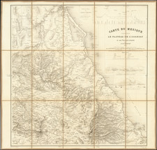
![(Second French Intervention in Mexico - Manuscript Map) Michoacan [and parts of Guanajuato and the Bajío region of Mexico]](https://storage.googleapis.com/raremaps/img/small/86018.jpg)