|
||

|

|
|

|
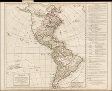
Scarce map of America by Gussefeld, highlighting the limited knowledge of the knowledgee of Western North America even after the completion of the recent explorations of Vancouver, Humboldt & Lewis & Clark.
The mythical Oregan River is still shown, although now quite tentatively so. The outline of Alaska is still quite incomplete.
In the northwest, a reference to "Fou Sang der Chinsen" refers to the discovery of the New World by the Chinese, prior to Columbus. Fusang or Fousang is a country described by the Buddhist missionary Hui Shen in 499 CE, as a place 20,000 Chinese li (about 7,000 to 10,000 kilometers) east of Da-han, and also east of China. Da-han is described as a place north-east of the country of Wo (southwestern Japan). Hui Shen went by ship to Fusang, and upon his return reported his findings to the Chinese Emperor. His descriptions are recorded in the 7th century Book of Liang (History of the Liang Dynasty) by Yao Silian. An earlier account, from the annals of the Han dynasty, also declares that in 219 BCE emperor Shi Huang sent "an expedition of young men and women to a wonderful country lying far off to the east, across the ocean, called Fu-Sang.
According to some historians, beginning with Joseph de Guignes ( Le Fou-Sang des Chinois est-il l'Amérique? Mémoires de l'Académie des Inscriptions et Belles Lettres, tome 28, Paris, 1761), the distances given by Hui Shen (20,000 Chinese li) would locate Fusang on the west coast of the American continent, when taking the ancient Han-period definition of the Chinese li. This is one of a small number of 18th century European maps which show Fusang along the Northwest Coat of America.
The map treats the place names along the West Coast of North America very simply, with a reference to Drake's landing at Bodega Bay, pre-dating the exploration of Vancouver, which formalized the names of many places on the West Coast. The treatment of the Rocky Mountains is similarly primitive, shown only a few years before Alexander Von Humboldt's explorations and research would radically rework the simple single cordillera model. In the Upper Northwest, the Columbia and Frazier Rivers (both unnamed) are shown and referenced apocryphally as the the Western or Oregan River.
Hawaii is shown (Sandwich Inseln). South America is still dominated by Spanish and Portugese colonists, on the eve of South America's Century of Revolution.

![(Early Mapping of America) Die Entdeckung Amerika's in ihrer Bedeutung für die Geschichte des Weltbildes [with:] Atlas](https://storage.googleapis.com/raremaps/img/small/103238.jpg)