|
||

|

|
|

|
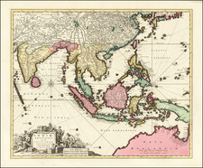
Rare 1813 edition of Reichard's map of the region, the first published with Fembo’s imprint, following issues by the Homann Heirs of 1795 and 1806.
The map extends northeast to Hawaii, and north to the region beyond Korea to Sakhalin Island (named). At the far west is the Straits of Malaca, Sumatra and Great Andaman Island, with the Philippines and Marianas Islands at the center of the regions depicted.
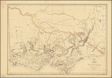
The map identifies Ulimaroa or Neu-Holland. The full coast of Australia is now explored, although the coastline is still far from well refined.
New Zealand inludes several dozen place names, although the Stewart Island is till attached to South Island.
Georg Christoph Franz Fembo bought the publishing house of Homann Heirs of Nuremberg in 1813, at which time he ordered improved or new maps from scientists as well, and he even drew new maps himself. All of Fembo’s folio-sized maps are rare.
Christian Gottlieb Reichard (1758-1837) was a German cartographer. Reichard studied law in Leipzig and found work as a town clerk in Bad Lobenstein. He had great personal interest in geography, history, and cartography, hobbies which gained him more renown than law. However, even after he began making maps, he continued working his clerk job, which gave him the financial stability to support his family.
Reichard is best known for his work on his Atlas des Ganzen Erdkreises in der Central Projection (Atlas of the Whole World in the Central Projection) in 1803 and the Orbis terrarum antiquus (Atlas of the Ancient World) of 1824. He is also likely the first published cartographer to adopt the Albers conic projection, in his map Die Vereinigten Staaten von Nord-America, nach den sichersten Bestimmungen, neuesten Nachrichten und Charten, in der Alber’schen Projection entworfen, (The United States of North America, after the safest regulations, latest news and charts, designed in the Alberian projection), where he references the Albers projection by name.
Reichard’s work was known by his contemporaries as highly accurate, and in fact this descriptor still holds up today. This accuracy, along with his skill, made him very publishable, and he worked on a number of atlases with other cartographers, such as Steiler’s Handatlas. Reichard’s style is simple but includes great detail, making his maps both recognizable at a glance and engaging upon deeper study.