|
||

|

|
|

|
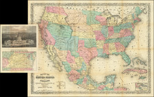
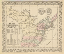
Rare Coast to Coast US Map with an Unusual Configuration for Michigan Territory
A nice example of Weiland's rare map of the United States.
In the 1820s, a few mapmakers began to show the United States from coast to coast, at a time when American claims to Oregon Territory were firming up, but the boundaries with both Spain (and later Mexico) and Britain (for the future British Columbia) were still uncertain. With the ratification of the Adams-Onis Treaty in 1819, the US and Spain had agreed to a largely unsurveyed and unexplored border from north of Texas to the Pacific Ocean, and in 1818, a U.S.-British agreement had established the border along the 49th parallel from Lake of the Woods in the east to the Rocky Mountains in the west, with the two nations also agreeing to a joint occupation of Oregon territory for 10 years, an arrangement that was extended for an additional 10 years in 1827.
Mapping the region offered greater complexity. While the first generation of explorers such as Lewis & Clark, Pike and Stephen Long had offered some basic outlines of the region and American and British Fur Traders were bringing a better understanding of the region, it was still largely unexplored unknown.
The present map is a marvelous amalgam by German mapmaker Carl Ferdinand Weiland, who would create at least 3 maps of the US between 1821 and 1826. The present map is substantially similar to the 1821 and 1824 maps. The most noteworthy update on the present map is the introduction of a very unusual configuration for Michigan Territory.
According to Arkway (in describing the 1824 edition of the map):.
The Library of Congress owns the only recorded example of the 1821 edition; neither edition is in OCLC or RLN. According to Wheat, Weiland's map "follows Lewis and Clark's map, but with this difference, that the Fraser [River] is missing while the entire Columbia is present. The result is that the United States is shown from the 42nd parallel extending north to take the entire Columbia watershed and from there to the sea. Despite the omission of the Fraser, the geography in the little-known west seems more up-to-date than the geography in the east. The shapes of the Great Lakes, for example, are unique or archaic. Lake Michigan is too long and narrow, and Weiland's Lake Superior is unlike any delineation in Mapping the Great Lakes Region (1977): the lake looks like a pair of lungs separated by several islands. Issued originally the same year that Missouri was admitted as a state in 1821, this publication of the Weimar Geographischen Instituts was one of the first European maps to recognize the controversial new state over which the Missouri Compromise was fiercely debated.
Indian tribes are identified throughout the western territories and estimates of their populations are provided. This is an early map to locate Champ d'Asile, a colony of Bonapartist refugees founded in Texas on the Trinity River in 1818. Spanish troops were dispatched from San Antonio to expel the colony, which was abandoned within the year. Champ d'Asile was included on the first edition of the map in 1821. Maps that locate the colony are uncommon. . . .
Carl Ferdinand Weiland (1782-1847) published two atlases, Atlas von Amerika (1824-28) and Algemeiner Hand-Atlas (1828-48). Weiland's large map presents the boundary of Texas in its then ambiguous state. Texas stands out on the map, having an ambitiously exaggerated Panhandle. Texas is designated Provinz Texas and is shown as part of Provinz Cohahuila, San Luis Potosi, Neu Santander, and even the eastern edge of New Mexico (Santa Fe is shown practically on the border). The northern boundary west of the Rocky Mountains extends north to take in the whole of the Columbia watershed.
One of the earliest coast to coast maps of the US published in Europe.
Rarity
This is the first example of the map we have seen on the market.
We previously offered an example of the 1821 in 2009.