|
||

|

|
|

|
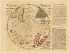
Terra Australis. A Vision of Australia Before Its Discovery.
Vellum Fragment from a Previously-Unknown 16th-Century Manuscript Wall Map of the World.
Unique manuscript map featuring Terra Australis, the adjacent islands of the Indo-Australian Archipelago, and the southern Indian Ocean, which was originally part of a monumental hand-drawn wall map of the world drawn in Italy at the end of the 16th century.
This remarkable survival depicts information which first entered European travel narratives with Marco Polo, and which appeared in the maps of Gerard Mercator, Petrus Plancius, and Arnoldo di Arnoldi. The map illuminates modern viewers of the European conceptions of Terra Australis, at a time before the first recorded discovery of Australia by Willem Janszoon in 1606, including representations of the inhabitants, flora and fauna of the largely mythical continent. The fragment also provides provocative evidence of the existence of large-scale manuscript Italian wall maps at a point when none were previously known to have existed.
The most striking aspect of the fragmentary representation of the Australian proto-continent is its abundant of illustrations, including trees, mountains, people, and mythical creatures. Over a dozen red city symbols are added, both along the coasts and within the interior of the Southland, illustrating a densely populated continent and multiple seaports.
Despite being a faded fragment, this hand drawn illuminated chart must be regarded as compelling and previously unknown documentation of the hypothetical pre-history of the fifth continent and an extraordinary artifact of 16th Century Italian artistic cartography.
Cartographic Contents
The map shows a portion of the Indian Ocean, Southeast Asia, and the undiscovered proto-continent of Australia. The Indo-Australian Archipelago is shown, including named islands such as Java (Giava Maggiore), Borneo (Borneo), and Java Minor (Giaua Minor), as well as an unnamed Sumatra and the Malaysian Peninsula. The map's lower section showcases a grand Austral-continent, filled with images of trees, mountains, people, and mythical animals and numerous red city symbols illustrative an an unknown indigenous population.
Italian Origins
The map's Italian origin is evident from the toponyms (Oceano orientale, Giaua maggiore), compass rose with Italian directions of the winds (S=Syroco; O=Ostro and L=Libeccio), and the long Italian text in the unknown Terra Australis. The map was originally the lower right quarter of a larger manuscript map of the world, created in Italy. The cartographic image is assumed to have been based on a specific printed world map, which led to the large wall map of the world in twelve sheets (106 x 189 cm), engraved in 1600 by the Flemish cartographer Arnoldo di Arnoldi for publisher Matteo Florimi in Siena.
Arnoldo de Arnoldi's wall map of the world was an attractively engraved work, but evidently not good enough to satisfy wealthy merchants and aristocrats. Instead of commercially available ordinary printed works, they wanted to own unique trophy versions to impress and outshine others. They consigned skillful artists to produce manuscript versions on vellum, thus creating true works of art. The printed model was broadly followed, but embellished with artistic and decorative elements, to make them as attractive as possible.
The text on the map follows that on Arnoldi's world map:
L'Isola detta giava maggiore circonda tre mila migl [ia com:] attesta Marco Paolo: soggetta al continuo impeto de venti, come refer quell della Scala, gli habitatori sono mori, e gentili tutti di piccola statura, corpo= lenti, con la faccia larga, e per il piu vano nudi, eccecetto che cuoprino le parti vergognose, sono superbi inhu [mani], crudely, l'Isola abondante di specierie
Translated: [The island of giava maggiore has a circumference of three thousand miles as stated by Marco Polo: subjected to the continuous violence of winds, as relates the one of La Scala, the inhabitants are moors and pagans all of short stature, corpulent, with broad face, and mostly they go naked, except that they cover the shameful parts, they are arrogant, inhuman, cruel, the island abounds in spices.]
La Scala is the neighborhood in Venice where Marco Polo lived. The note about the three thousand miles circumference is found in several medieval sources. In contrast, the information on the inhabitants with broad faces comes from the Itinerario of Ludovico de Varthema. The Italian explorer Varthema is believed to be the first European to visit the Spice Islands in 1505. The Portuguese would reach them only in 1512.
Ultraviolet Imaging
Although the fragment's painted image has become faint due to its use as a bookbinding, multispectral imaging, namely, ultraviolet (UV) light imaging, reveals attractive artwork throughout the map. This imaging indicates that the map was created for decorative and informational purposes rather than for navigational use at sea. UV images uncover beautifully-dressed Southlanders, a gryphon (winged dragon), and other mythical animals, along with decorative elements like compass roses, ships, sea monsters, and fish in the Indian Ocean and Indonesian waters. Additional multispectral imaging could reveal even more details and be used to create a modern artist reconstruction to display in conjunction with the fragment.
Rarity
A search of the MEDEA Chart Database uncovers no large manuscript Italian wall maps from this or any adjacent period. We conclude that this chart stands as evidence of a previously unrecognized Italian manuscript world map tradition.
Chet van Duzer, Henricus Martellus's World Map at Yale (c. 1491), 2019.
Van der Heijden, H.A.M. 'Wie was Arnoldo di Arnoldi?'. In: Caert- Thresoor, 18 (1999) no. 2, pp. 37-40.
Shirley, R. The Mapping of the World. London 1983.
![[Philippine Islands, Taiwan, etc] Partie des Isles Philippines; Partie de la Chine; Partie de L'Ile Gilolo; Partie de L'Isle Borneo](https://storage.googleapis.com/raremaps/img/small/93579.jpg)