|
||

|

|
|

|
Rare First State!
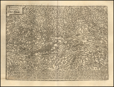
First state of this important early map of Bavaria (and Baden-Württemberg), first published by Paolo Forlani in 1570.
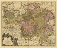
The map is centered on the Danube River, extending south to Lake Constance and the Alpine regions of Germany and north to the Main River, west to the Rhine. Major Cities include Stuttgart, Munich and Nuremberg.
Four years after Forlani's first map of Bavaria published in 1566, Forlani created this second map of Bavaria, based upon Sebastian Munster's Swabia and Bavaria XI. Nova tabula. Bifolco credits the work to the publisher Claudio Duchetti, during his short Venetian period. The plate was then brought to Rome by Duchetti, where it was later acquired by Giovanni Orlandi in 1602, and then sold by him to Hendrik van Schoel.
The present map is more elegantly engraved than the 1566 map and includes additional detail, although the details of the rivers, lakes and mountains is largely the same. There are also a number of different place name spellings and abbreviations.
States of the map and rarity
- 1st State: imprint the year M.D.LXX. Paolo Forlani Veronese f.
- 2nd State: No known surviving examples (imprint of Giovanni Orlandi and the date 1602 assumed).
- 3rd State: Imprint Henric van Schoel formis romae 1602 added to the cartouche above Forlani's name.
All states of the map are rare.
The Lafreri School is a commonly used name for a group of mapmakers, engravers, and publishers who worked in Rome and Venice from ca. 1544 to 1585. The makers, who were loosely connected via business partnerships and collaborations, created maps that were then bound into composite atlases; the maps would be chosen based on the buyer or compiler’s interests. As the maps were initially published as separate-sheets, the style and size of maps included under the umbrella of the “School” differed widely. These differences can also be seen in the surviving Lafreri atlases, which have maps bound in with varying formats including as folded maps, maps with wide, trimmed, or added margins, smaller maps, etc.
The most famous mapmakers of the School included Giacomo Gastaldi and Paolo Forlani, among others. The School’s namesake, Antonio Lafreri, was a map and printseller. His 1572 catalog of his stock, entitled Indice Delle Tavole Moderne Di Geografia Della Maggior Parte Del Mondo, has a similar title to many of the composite atlases and thus his name became associated with the entire output of the larger group.
Paolo Forlani (fl. ca. 1560-1571) was a prolific map engraver based in Venice. All that is known of his life are his surviving maps and prints, of which there are almost 100 (185 with later states included in the total). He also produced a globe and two town books. It is likely he came from Verona and that he died in Venice in the mid-1570s, possibly of the plague.
![Palatinatus Bavariae Descriptio . . . [with] Wirtenbergensis Ducatus...](https://storage.googleapis.com/raremaps/img/small/65838.jpg)
![(Mainz, Würzburg and Sion) Moguntia, Germaniae Metropolis, ad Rheni ripas Urbs Celeberrima, mercatorum frequentia . . . [and] Herbipolis Comuiter Wirtzburg Orientalis Franciae Metropolis [and] Sedunum, primaria & Metropolitica Valesiae urbs . . .](https://storage.googleapis.com/raremaps/img/small/55078mp2.jpg)