|
||

|

|
|

|
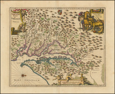
The First Large Format Map of Chatham County, Georgia.
Fine separately issued map of Chatham County and the environs of Savannah, Georgia - the earliest large format map of the County.
This impressive map is the only map for Chatham County, Georgia, published before the twentieth century. Highly detailed and decorative, it is a remarkable record of the environs of Savannah from the Reconstruction period.
Designed as a real estate map, it shows every existing plot of land in the county with the current owners named. Although Savannah had outgrown its eighteenth century footprint, many of the surrounding forty-five acre farm plots and 600 acre square outlots established by Oglethorpe in 1733, are still undeveloped and are laid down. The county's extensive road and railroad networks are shown. Arable land is shown in yellow, with swamps and wetlands colored green. A lengthy informative text in the upper left-hand corner included the names of thirty-seven local surveyors whose plats were "the foundation of this map."
Due to its accuracy and detail, Platen's map is one of a small handful of definitive cartographic sources for Savannah and the surrounding area. It has been consulted in boundary disputes between the States of Georgia and South Carolina, and is frequently used for historical and archaeological investigations. These include an attempt to determine the age of a plank road that parallels present-day Highway 80, and to locate the exact site of the Ten Broeck Race Course, where the largest slave auction in Georgia history took place in 1859.
Rarity
Scarce. OCLC lists four examples: Cornell, Library of Congress, Georgia Southern, and University of Alabama. We have located additional copies at the Georgia Historical Society and the Office of the Surveyor-General Department, State of Georgia.
![[ Port Royal, South Carolina ]](https://storage.googleapis.com/raremaps/img/small/81298.jpg)