


|
||

|

|
|

|
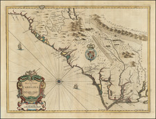
Stock# 91990
Description
Detailed U.S. Coast & Geodetic survey of the area around Morgan's Island in South Carolina.
The chart includes much in the way of bathymetric detail as well as exacting treatment of the areas directly adjacent to the water.
Notes on the chart explain that it was based on the following surveys:
Triangulation by C.P.Bolles and C.O. Boutelle Assistants between.... 1851 & '60
Topography by John Seib, W.H.Dennis and C.Hosmer Assistants between... 1859 & '71
Hydrography by Lieuts. Comdy. J.N.Maffitt, I.P.Bankhead U.S.N.and C.Hosmer Assistants between 1857 &'71
The chart was issued in March 1880 by C.P. Patterson, Superintendent. It was verified by J.E. Hilgard, Assistant in charge of Office.
The chart was first published in 1872.
Condition Description
Purple ink stamp in the lower-left corner "Printed Feb 2 1893".
![[ Carolinas & Georgia ] Carte De La Caroline Et Georgie . . .](https://storage.googleapis.com/raremaps/img/small/99744.jpg)
![[Carolina]](https://storage.googleapis.com/raremaps/img/small/89687.jpg)