


|
||

|

|
|

|
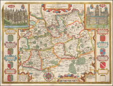
Rare Jansson map of Herefordshire, published in the middle of the 17th century and showing Herefordshire.
The map shows the county in fine detail. Towns and cities are shown, and the map is centered on Hereford. Fine Dutch-style cartouches appear in the upper right and lower right of the map, with the lower cartouche remaining blank.
Hereford, located in the Welsh Borders, was one of the smaller English ceremonial counties. Its geography is dominated by the hills to the southwest and the River Wye, both visible on the map.
This map originally appeared in Jansson's atlas of English counties, one of the books in his Atlas Major. This volume was succeeded by an atlas of Scottish counties.
Jan Janssonius (also known as Johann or Jan Jansson or Janszoon) (1588-1664) was a renowned geographer and publisher of the seventeenth century, when the Dutch dominated map publishing in Europe. Born in Arnhem, Jan was first exposed to the trade via his father, who was also a bookseller and publisher. In 1612, Jan married the daughter of Jodocus Hondius, who was also a prominent mapmaker and seller. Jonssonius’ first maps date from 1616.
In the 1630s, Janssonius worked with his brother-in-law, Henricus Hondius. Their most successful venture was to reissue the Mercator-Hondius atlas. Jodocus Hondius had acquired the plates to the Mercator atlas, first published in 1595, and added 36 additional maps. After Hondius died in 1612, Henricus took over publication; Janssonius joined the venture in 1633. Eventually, the atlas was renamed the Atlas Novus and then the Atlas Major, by which time it had expanded to eleven volumes. Janssonius is also well known for his volume of English county maps, published in 1646.
Janssonius died in Amsterdam in 1664. His son-in-law, Johannes van Waesbergen, took over his business. Eventually, many of Janssonius’ plates were sold to Gerard Valck and Pieter Schenk, who added their names and continued to reissue the maps.
![[ Wight ] Isle de Wigh](https://storage.googleapis.com/raremaps/img/small/98047.jpg)
![[ Oxford and Windsor Castle ] Oxonium nobile Anglie oppidum Septenrionalem . . . [with] Vindesorium celeberrimum Anglia castrum locus amoenißimus aedificia magnifica . . .](https://storage.googleapis.com/raremaps/img/small/96906.jpg)
![[Somerset] Comitatus Somersettensis Somerest-Shire](https://storage.googleapis.com/raremaps/img/small/91564.jpg)