


|
||

|

|
|

|
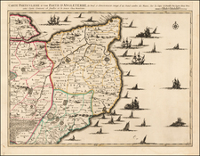
Rare sea chart of the coast of England, focused on the Norfolkshire, Lincolnship and Yorkshire coastlines, "constructed by John Purdy."
Includes inset maps of:
- Coast of Suffolk
- Lynn Deeps
- Mouth of the Humber River and Estuary
- Boston Deeps
- Great Grimsby
- Lowestuff Roads
- Lord Nelson's Monument
Richard Holmes Laurie (1777-1858) was the son of mezzotint engraver Robert Laurie, who had taken over Robert Sayer's publishing house with James Whittle in 1794. Richard Holmes Laurie joined in a partnership with Whittle when his father retired in 1812. The name of the firm then switched from Laurie & Whittle to Whittle & Laurie. Whittle died in 1818, leaving Richard Holmes to continue publishing alone as R. H. Laurie.
When the Hydrographic Office opened in 1795, it was tasked with creating and producing all the nautical charts for the Royal Navy so as to wean the Navy off dependence on foreign charts. By the 1820s, private publishers were augmenting HO charts and competing with them, including Richard Holmes Laurie. Richard gave up publishing anything except nautical materials by 1830. He also sold charts to Trinity House, the lighthouse and maritime safety fraternity. He died in 1858.
The firm continued to print under the name R.H. Laurie even after 1858. Later, the firm was managed by Laurie’s draughtsman, Alexander George Findlay, and, later, Daniel and William Kettle.
John Purdy was a hydrographer and the chief chart maker for Richard Holmes Laurie. He died in January 1843 of gangrene.

![[England, Scotland & Wales]. Parte Settentrionale del Regno d'Inghilterra . . . (with) Parte Meridionale del Regno d'Inghilterra . . .](https://storage.googleapis.com/raremaps/img/small/89516.jpg)