|
||

|

|
|

|
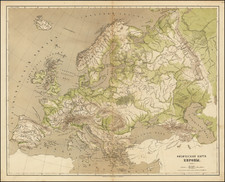
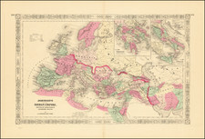
Fine Map of Europe from the Famous Mercator-Hondius Atlas
Handsome old-color example of Hondius' second map of Europe, initially issued in 1606 as part of Hondius’ first edition of Mercator’s atlas.
The map shows the continent surrounded by Anatolia, the Eastern Mediterranean, the Barbary Coast, a sliver of Greenland, and part of Labrador. Iceland is depicted with many place names.
Although a suggested Northeast Passage is obscured by the cartouche in the upper right corner, the search for the waterway is nevertheless represented by the coastline of Nova Zembla. This archipelago was the subject of much speculation in Europe at the time thanks to the reports of the three voyages of Willem Barentsz in the 1590s.
The specious island of Frisland is also included here. Another mythical landmass is the wandering island of Hy Brasil, which is included west of Ireland. The latter island is an enduring Atlantic chimera that came from Celtic folklore. It ranges on maps from just off the west coast of Ireland to the area around the Azores. The island was initially described as a rich paradise not unlike Atlantis; it emerged from the depths for a short period and then would disappear. It started to appear on portolan charts in the fourteenth century and continued to be a stalwart of maps and charts into the nineteenth century. The island was the subject of a fanciful pamphlet by Richard Head in 1675. Despite no accurate reports of its whereabouts, the island appeared on Admiralty charts and other reputable maps for centuries, usually in the latitude of 51°N and at a longitude of 17°W.
The map is complemented by attractive strapwork cartouches carrying the scale bar, title, author, and a description of Europe’s geography and the peopling of the world by Noah’s sons. There are also decorative ships in the Mediterranean and the Atlantic, as well as sea creatures surfacing in several places.
Jodocus Hondius the Elder (1563-1612), or Joost de Hondt, was one of the most prominent geographers and engravers of his time. His work did much to establish Amsterdam as the center of cartographic publishing in the seventeenth century. Born in Wakken but raised in Ghent, the young Jodocus worked as an engraver, instrument maker, and globe maker.
Hondius moved to London in 1584, fleeing religious persecution in Flanders. There, he worked for Richard Hakluyt and Edward Wright, among others. Hondius also engraved the globe gores for Emery Molyneux’s pair of globes in 1592; Wright plotted the coastlines. His engraving and nautical painting skills introduced him to an elite group of geographic knowledge seekers and producers, including the navigators Drake, Thomas Cavendish, and Walter Raleigh, as well as engravers like Theodor De Bry and Augustine Ryther. This network gave Hondius access to manuscript charts and descriptions which he then translated into engraved maps.
In 1593 Hondius returned to Amsterdam, where he lived for the rest of his life. Hondius worked in partnership with Cornelis Claesz, a publisher, and maintained his ties to contacts in Europe and England. For example, from 1605 to 1610, Hondius engraved the plates for John Speed’s Theatre of the Empire of Great Britaine.
One of Hondius’ most successful commercial ventures was the reprinting of Mercator’s atlas. When he acquired the Mercator plates, he added 36 maps, many engraved by him, and released the atlas under Mercator’s name, helping to solidify Mercator’s reputation posthumously. Hondius died in 1612, at only 48 years of age, after which time his son of the same name and another son, Henricus, took over the business, including the reissuing of the Mercator atlas. After 1633, Hondius the Elder’s son-in-law, Johannes Janssonius, was also listed as a co-publisher for the atlas.
![[Europe: Air Mail Routes] Carte des lignes postales aeriennes internes et internationales Europe pubilee par le Bureau International de l'Union postale universelle Berne, Avril 1937](https://storage.googleapis.com/raremaps/img/small/41144.jpg)