|
||

|

|
|

|
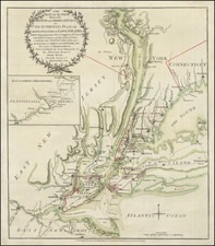
Boston in the Wake of the Battle of Bunker Hill
The map offers a highly detailed depiction of Boston and the neighboring Charles Town during the first months of the American Revolution.
The map depicts the peninsula of Boston with Charles Town to the north, both surrounded by the Charles River and Boston Harbor. Streets are meticulously plotted, with several intersections marking historic junctions in the town. Notable streets such as Milk Street, Orange Street, and Union Street can be discerned, adding a sense of familiarity to those aware of Boston's cityscape.
The wharfs extending into the harbor are well delineated. Waldo's Wharf and Hudson's Point are distinctively labeled, presenting the prime trade hubs of the period. The South Battery and North Battery are clearly marked along the waterfront, representing defensive structures protecting the city from potential waterborne threats.
Among other unique features, the map exhibits the outlines of significant areas like Battery Common and Dock Square, along with landmarks like Boston Hill and Corps Hill, showcasing the city's unique topography. Mill Pond, is rendered towards the city's northwestern corner. The Magazine, a storage area for military ammunition, is also depicted, underscoring popular interest in fortified Boston among British readers.
Across the river to the north, Charles Town is represented, with visible buildings greatly damaged, noted as the 'Ruins of Charles Town,' a grim testament to the recent Battle of Bunker Hill. The Charles Town Ferry is shown, indicating the connection between these two integral towns.
In all, a fascinating look into what was then one of the first war time maps of Boston available to London's literate populace.
The Gentleman’s Magazine was a British publication that helped to normalize the use of maps in support of articles and features. It was founded in 1731 by the prominent London publisher Edward Cave, a pioneer in periodical journalism. The magazine continued in print for nearly two centuries, shuttering production in 1922.
This was the publication which first used the word “magazine”, from the French for storehouse. Cave wanted to create a storehouse of knowledge and he employed some of London’s best writers to fill his pages: Samuel Johnson gained his first regular employment by writing for the Gentleman’s Magazine. Other famous contributors included Jonathan Swift.
The publication covered a broad range of topics, from literature to politics, and, from 1739, frequently used maps as illustrations. The first map they printed was a woodcut of Crimea; the second was a fold-out map of Ukraine by Emanuel Bowen. Maps were used to show battle lines, to chronicle voyages, and to educate about areas with which Britain traded. Certain geographers, like Thomas Jefferys, contributed several maps to the publication.
![(US Navy - Chesapeake and the Shannon) [Manuscript signal book for the USS Chesapeake, taken by a British sailor after the Chesapeake was captured by the HMS Shannon in 1813]](https://storage.googleapis.com/raremaps/img/small/84354.jpg)
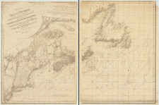
![[Portland & Cape Elizabeth to Moskito Island -- Centered on Kennebec River]](https://storage.googleapis.com/raremaps/img/small/50079.jpg)