|
||

|

|
|

|
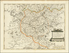
The First French Map Made Using Triangulation. The Birth of the Cassini Family's Cartographic Output.
Fine example of Cassini's map of the Ile-de-France region, a cartographic milestone for scientific surveying techniques.
This map represents the start of the great Cassini family's great mapmaking project to create the most accurate map of any nation. Following Louis XIV's employment of Jean-Dominique Cassini in 1671 as director of the Paris Observatory, he set out to complete a map of the region. The triangulation for the map was done by the members of the French Royal Academy of Sciences Gilles Personne de Roberval and Abbé Jean Picard alongside the engineer David du Vivier and three to five assistants.
The map extends northwards along the Oise River, westwards towards Mantes, eastward along the Marne, and south towards Fontainebleu. Cities, forests, villages, topography, and more are all shown. The old and current walls of Paris are denoted, alongside the city's major arteries. Extravagant French School cartouches appear in the four corners of the map with symbols including the seals of Paris and Colbert.
This map was particularly important in the history of scientific surveying as Picard realized, during its construction, that an exact measurement of the Earth's meridian would be necessary. Along the road to Fontainebleu, four-toises poles were laid down, which, coupled with astronomical observations, provided the most accurate measurement of the meridian.
This map was engraved by de la Pointe in 1678.
The Carte and the Early History of the Cassini Family
Jean-Dominique Cassini started his career at the Panzano observatory near Bologna where he made several important measurements relating to proving Kepler's heliocentric theory. He gained further fame by determining the rotational periods of Mars and Jupiter. Cassini was subsequently recruited by Jean-Baptiste Colbert to move to France to work for King Louis XIV.
Upon moving, his first exploit was to determine the size of France, which, famously, turned out to be significantly smaller than believed by the Sun King. Alongside Cassini's astronomical observations, he also started a mapmaking project for the King. The present Carte Particuliere was the first of these projects and was the first map produced in France to use triangulation.
Cassini's descendants continued with this project until the French Revolution. The general project was finished in 1815 and included 181 sheets, spanning five generations of the Cassini family.
![[ Paris ] Plan Routier De La Ville et Faubourg De Paris 1772](https://storage.googleapis.com/raremaps/img/small/92313.jpg)
![[ Paris ] Le Nouveau Plan de Paris Dresse sur le Memoires de Mr. Jouvin de Rochefort Tresorier de France, Corrige, Augmente, et Enrichi de Veues de Versailles Situees aux Environs Dresees sur le Lieux.](https://storage.googleapis.com/raremaps/img/small/103832.jpg)