


|
||

|

|
|

|
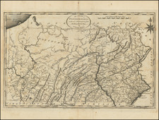
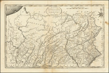
The First Map of the State of Pennsylvania From Indigenous Surveys
Reading Howell's map a cartographic landmark in the mapping of Pennsylvania and one of the most influential maps of Pennsylvania to be published.
First issued in 1792, Howell's map is the first large format map of Pennsylvania published in America following the Revolution. Wheat & Brun describe the map as the best map of Pennsylvania published in the 18th Century.
Howell's map is earliest map of Pennsylvania to show its exact boundaries, including the western limits. For the first time on a printed map, Howell records the information gathered from the many original regional and local surveys made after the Revolutionary War and during a time of rapid westward expansion. Originally issued in four sheets (with copper plates engraved per Howell's instructions in London, but final publication in Philadelphia), the map was published over a period of several months, with many additions and corrections to the map of historical interest, and which are also useful in identifying the various states of the four plates.
A reduced 2 sheet edition of Howell's map was subsequently issued 1792. Finally, this very rare enlarged edition was published in 1811 (the present example), which adds for the first time a large decorative cartouche not present in earlier editions. Published by Kimber & Conrad & Johnson & Warner in 1811, the map was later re-issued in 1816 and 1817.
The map remained the most accurate map of Pennsylvania until the publication of John Melish's map of Pennsylvania in 1820.
Reading Howell (1743–1827) was a distinguished American engineer, surveyor, and landowner, based in Pennsylvania, whose professional life spanned the transformative period from colonial times through the early years of the United States. Renowned for his surveying and cartographic skills, Howell played a pivotal role in the mapping and development of Pennsylvania during the late 18th and early 19th centuries.
Born into the era preceding the American Revolutionary War, Howell's contributions to surveying began to gain prominence as the newly formed United States embarked on establishing its geographic and civic infrastructures. His work included detailed surveys of major Pennsylvania waterways—the Delaware, Lehigh, and Schuylkill Rivers—which were critical for commerce and transportation in the burgeoning nation.
In 1789, recognizing his expertise, the Pennsylvania assembly commissioned Howell to create a comprehensive map of the state for the substantial sum of two hundred pounds. Published in 1792, this map was the first of Pennsylvania to be issued after the American Revolutionary War. It stood out as the most detailed and accurate representation of the state at the time, incorporating extensive cartographic data accumulated by both American and British military surveyors during the war. This map not only served as a vital tool for state planning and development but also as a significant artifact in the cartographic history of the United States.
From 1804 until his death in 1827, Howell held prominent civic roles in Philadelphia, including "Principal City Surveyor" and "City Regulator." In these capacities, he was intimately involved in urban planning and the resolution of land disputes, leaving an indelible mark on the physical and legal landscape of the city. His surveys and maps became authoritative resources, used extensively in legal settings and city planning.
Howell’s legacy is cemented in the annals of American surveying and cartography, with his early works remaining a reference point for historians and cartographers studying the post-revolutionary period. His meticulous records and maps continue to be valued for their historical significance and precision, reflecting the foundational years of American geography and the critical role of surveyors in shaping the nation’s early development.
![(Map Seller's Canvassing Book) Subscribers to the Map of Greene County by Simon J. Martenet, Surveyor & Civ. Eng., Baltimore, Md, 1858 [Manuscript subscription book for Martenet map of Greene Co., Pennsylvania]](https://storage.googleapis.com/raremaps/img/small/77428.jpg)
![Notes on the State of Virginia [with the map:] A Map of the country between Albemarle Sound, and Lake Erie, comprehending the whole of Virginia, Maryland, Delaware, and Pensylvania, with parts of several other of the United States of America. Engraved for the Notes on Virginia.](https://storage.googleapis.com/raremaps/img/small/55181.jpg)