|
||

|

|
|

|
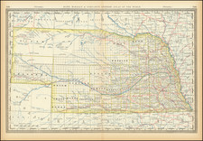
The First Map of the Union Pacific.
This is the second known example of the final version of Peter Anthony Dey's map of the first section of the Union Pacific Railroad, the map which would establish the first portion of the route of the Transcontinental Railroad.
In 1862, Anthony Dey, with the assistance of Grenville Dodge, undertook a survey on behalf of the Union Pacific Railroad. The survey set both a primary proposed route and other preliminary lines of survey (1) over the Cheyenne Pass and the Bridger Pass, (2) between Omaha and the Platte Valley, and (3) between Belleview and the Platte Valley, and several other preliminary lines. The results of the survey appear on this map.
The map illustrates the routes surveyed by Dey across the eastern portion of Nebraska Territory. A version of the map, either an early printed version or a manuscript version, was presented by Dey and Thomas Durant to Abraham Lincoln, and it was Dey's work that persuaded Lincoln to choose Omaha as the starting point on the Missouri River for the route of the Transcontinental Railroad from Omaha to the Pacific Ocean.
Later, Dey would be named the Chief Engineer of the Union Pacific Rail Road and remain in this position until resigning in 1865, in protest of the business dealings of the Railroad, which would become known as the Crédit Mobilier scandal.
Union Pacific and Transatlantic Railroad
The Union Pacific Railroad was a crucial part of American history, connecting the east and west coasts of the United States for the first time. Construction of the Union Pacific began in 1863, when President Abraham Lincoln signed the Pacific Railroad Act into law. The Act provided government support and land grants to two railroad companies, the Union Pacific and the Central Pacific, to build a transcontinental railroad.
The Union Pacific was tasked with building the railroad westward from Omaha, Nebraska, while the Central Pacific was responsible for building eastward from Sacramento, California. The two companies were in a race to meet in the middle, with the goal of connecting the entire country by rail. A number of other railroad lines are shown, all in heavy black lines.
States of the Map and Rarity
The present example is one of two known states of the map.
The first state appears to pre-date the first construction of the railroad. It is substantially larger than the present map (at 89 x 183 cm). There is less topographical detail, the railroad line is not cross-hatched, the map lacks a compass, and the title is in simple block letters, lacking the J & O Seymour imprint. It also lacks a decorative border. OCLC locates 2 examples of the first state (Library of Congress and Penn State).
The second state includes a decorative border, title with flourished lettering, additional topography, additional railroad routes in dashed lines, and the J & O Seymour imprint, among other additions. This is a photo-lithographic reduction probably published around 1865, as the railroad construction was under way.
OCLC locates only 1 example of the second state (Yale).
Peter Dey, together with a young assistant by the name of Grenville Dodge, is best known as leading the Union Pacific Railroad surveys in 1863 which resulted in the creation of a map which would be presented to President Abraham Lincoln, which resulted in Lincoln's selection of Omaha as the terminal point for the Transcontinental Railroad. Thereafter, Dey would become the UPRR's chief engineer, overseeing the survey of the route across the Black Hills at Cheyenne Pass and on to Utah and line's joinder with the line of the Central Pacific Rail Road, thereby completing the Transcontinental Railroad in May 1869.
Dey graduated from Geneva (now Hobart) College of Geneva New York. Thereafter, he began work work the New York and Erie Railroad Company as civil engineer. In 1849, he worked for the state of New York on the Cayuga & Seneca canal, building locks at Seneca Falls. Following this, he was engaged in the same line of work and for nearly the same length of time on the Erie canal at Port Byron. In the fall of 1850, worked for the Michigan Southern Railroad on its link to Chicago. In 1852, he worked with the Chicago & Rock Island Railroad, being in charge of division work from Peru to Sheffield, Illinois. There, he met Grenville M. Dodge, who afterward became famous as a general in the Civil War and prominent in railway construction. Mr. Dey gave General Dodge his first employment in railroad work.
Dey was engaged in various railway construction enterprises in Illinois until 1853, when he came to Iowa City, bringing with him General Dodge. In Iowa City he made the surveys for the Rock Island road from Davenport to Council Bluffs via Iowa City and Des Moines. In 1860 he was elected mayor of Iowa City.
Beginning in 1862, Dey began work with the Union Pacific Railroad, where he conducted the first survey and construction work of the Union Pacific Railroad. In September, 1862, he made a reconnaissance of the prospective route from the Missouri River to the Salt Lake Basin, with a view to ascertaining a practicable route and the probable resources of the country to be developed. He recommended against the proposed route via Denver, preferring a route crossing the Black Hills at Cheyenne Pass, which would be adopted as the final route of the first trans-continental railway.
In 1863, Dey, along with John A. Kasson, Thomas C. Durant, and T. J. Carter, went to Washington to ask the president to fix the eastern terminals of the proposed road. Dey had carefully prepared a map showing the approaches of the Chicago, Burlington & Quincy, the Chicago & Northwestern, and the Chicago, Rock Island & Pacific railways. From this map Mr. Lincoln decided that Omaha, Nebraska, would be the terminal for the western road.
Also in 1863, working with Thomas C. Durant, Dey ran some preliminary lines of survey over the Cheyenne Pass and the Bridger Pass, also between Omaha and the Platte Valley, and between Belleview and the Platte Valley, and at other points. This work was finished early in the fall of 1863, and on December 30, 1863, he was appointed chief engineer of the Union Pacific Rail Road.
Dey considered on as Chief Engineer until resigning in 1865 because of disagreements with Thomas Durant over the handling of business dealings, which would come to be known as the Crédit Mobilier scandal. Crédit Mobilier was a sham construction company chartered to build the Union Pacific Railroad by financing it with unmarketable bonds. It also provided a mechanism to dispense the immense profits from building the railroad to the board of directors and its shareholders.

![[ Western United States -- Massive Idaho Territory ]](https://storage.googleapis.com/raremaps/img/small/99057.jpg)