


|
||

|

|
|

|
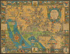
Fine early pictorial map of Washington, D.C. published by Houghton Mifflin in 1926.
The map shows the city streets of Washington against a yellow background, including elegant vignettes of its major buildings and monuments. The image is bordered by historical vignettes, including caricatures of important historical maps in each corner.
The map adapts the style popularized by McDonald Gill's Wonderground Map of London. Edwin Olsen and Blake Clark collaborated on a series of pictorial maps of American cities for Houghton Mifflin Company in 1926, including Boston, Philadelphia and Washington, D.C.
As noted by Hornsby, the map is:
the most prestigious in the series . . . [I]t was decided that the White House would occupy the center of the sheet, as ‘this is the appropriate position for it’. They also set the maps boundaries. As Olsen recounted, ‘the northern boundary shall be determined by and include Sheridan Circle because… of its social interest; going East we take in everything up to the Library of Congress, beyond which there is little of interest; on the South, though we can only actually include up to L Street, I think by using a little license, as we have on the other maps, we will be able to give sufficient indication of the War College and United States Navy Yard, and by the same means we will be able to get in Arlington Cemetery, Georgetown College, and the United States Naval Observatory in the West’”
(Hornsby, page 20).