


|
||

|

|
|

|
Stock# 91682
Description
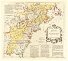
Interesting late 18th Century map of the United States, published on the eve of the Louisiana Purchase.
The map reflects a number of early changes from the original 13 colonies:
- The District of "Main" is shown -- statehood would not come until 1820
- Vermont is shown -- statehood granted in 1791
- Kentucky is shown in a very tentative configuration -- statehood granted in 1792
- "Tennassee" is shown is also tentative -- statehood granted in 1796
- A massive Western territory is shown, subsuming all of the area of the future Jeffersonian (and non-Jeffersonian) states.
- West of the Mississippi River, the entire region is Spanish Louisiana, pre-dating the Third Treaty of San Ildefonso where Napoleon secretly acquired Louisiana from Spain (1800) and the Treaty of Aranjuez (1801)
- East Florida and West Florida are still shown.
Condition Description
Overall toned and soiled.

![[Dutch Language Edition!] General Map of the Pennsylvania Railroad and its Connections](https://storage.googleapis.com/raremaps/img/small/80450.jpg)