
This item has been sold, but you can enter your email address to be notified if another example becomes available.


|
||

|

|
|

|
Stock# 91678
Description
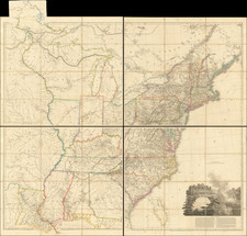
Early map of the United States, showing the region shortly after the Adams Onis Treaty of 1819.
Arkansas Territory is shown in its "double wide" configuration, characteristic of the 1820s. Wisconsin Territory appears on the map. The territorial name began appearing about 1835.
A large section is called "Western States", extending to the Rocky Mountains and showing the cartographic details reminiscent of the 1830s.
![A Geographical Chart: or, A Scheme, Comprehending The Most Important Particulars Relative To The Geography of North and South-America. : Designed to be an Auxiliary to the Student. Carefully Compiled from the Best authorities, by Amos Bingham [Copy-Right Secured]](https://storage.googleapis.com/raremaps/img/small/41406.jpg)
![[ Rotary Club International ] USCB Districts of Rotary International as of 1 July, 1958](https://storage.googleapis.com/raremaps/img/small/90418.jpg)