The item illustrated and described below is sold, but we
have another example in stock. To view the example which
is currently being offered for sale, click the
"View Details" button below.


|
||

|

|
|

|
Stock# 91677
Description
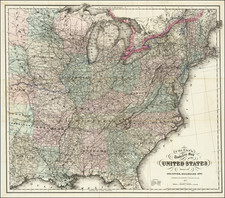
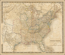
Scarce map of the United States, published in London.
The map covers the United States west to the Rocky Mountains. Texas is shown as part of the United State, as is a truncated New Mexico Territory.
The large "Western Territory" and lack of any territorial boundaries west of the Missouri River suggest that the map was published immediately after the Mexican-American War in 1848, but before territorial designations were given to the areas which would become Kansas, Nebraska and Dakota Territories, and long before the creation of Colorado Territory.