


|
||

|

|
|

|
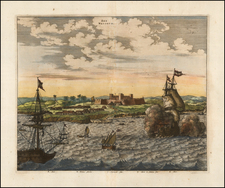
First News of the Dutch Siege of San Salvador -- The Dierick Ruiters View
First edition of this scarce view of the Siege of San Salvador by Claes Janszoon Visscher & Hessel Gerritsz, including the news text below.
Drawn from a plan of Bahia created by Dierick Ruiters, the present view shows the Dutch fleet in the Bahia de Todos Santos, with taking cannon fire for Portuguese fortified positions on either side of the Bay (Tapasiepe and S. Antonio). Along the waterfront, smaller fortified positions are firing on the approaching Dutch ships, with several Portuguese ships taking defensive positions returning fire and at least one Portuguese ship on its side.
At the upper right, a Dutch landing party is already ascending the road up the hill to San Salvador, having crested the first hill, with the gates of the city before them.
The plan depicts the taking of San Salvador by the Dutch in 1623, along with a contemporary account of the Siege. At the beginning of the text, Visscher notes that the text was "commissioned by the directors of the West India Company" (‘ter Ordonnantie van de E. Heeren Bewinthebberen der geoctroyeerde West-Indische Compagnie’).
As noted by Johannes Keuning (Imago Mundi, Vol. 6, (1949), pp. 48-66):
The first great enterprise of the West India Company was the dispatching of a fleet of 26 ships in Dec. 1623 under the control of the admiral, Jacob Willekens and the vice-admiral Pieter Pietersz. Heyn. The intention was the conquest of San Salvador, at the Bahia de Todos os Santos. This intention was completely attained in five days. Of this memorable act an engraving appeared in the same year. It is a picture of the Bahia de todos os Santos in Brasil and a view of the town S. Salvador, situated on the top of the mount on the bay; in the bay lies the whole Dutch fleet.
The Portuguese settled Salvador in the mid-16th Century and the City quickly rose to become the capital of the region and the most important sea port and financial center in the region. The town was sacked and taken as part of a Dutch invasion in 1623-24, before being retaken by the Portuguese the following year. The Dutch again attacked Salvador in 1627. Following this attack, Gerritsz prepared several new maps and illustrations of the invasion.
As noted by Furtado,
This event constituted an important episode of the Dutch conquest of the Northeastern sugar area of Brazil, an invasion whose flux and reflux extended from 1624 to 1654 in the context of the disputes between the Netherlands and Spain (then a united Crown with Portugal), caused both by the independence of the former and by the competition for the colonial commercial circuits until then monopolized mainly by the Iberian powers.
Dierick Ruiters
The work is based upon a sketch drawn by Dierick Ruiters (also known as Dierick Ruyters or Dirck de Ruyter), a Dutch navigator who is known for his images and descriptions of the coastal regions of West Africa and Brazil.
Ruiters seems to have had extensive experience in seafaring along the African coast, between Senegal and Angola, probably before 1612, after which time he left for Brazil, and in 1617 he visited Sergipe (north of Bahia ). The following year he was captured by the Portuguese in Rio de Janeiro and taken to Pernambuco. During his relocation he visited Bahia de Todos os Santos and Salvador. After 2½ years he managed to escape and returned to the Netherlands.
Back in the Netherlands he wrote the Tortse der Zee-vaart, a book of primarily sailing instructions for Africa and America, based on the work of the Portuguese Manuel de Figueiredo. Ruiters added extensive descriptions of the various countries, based on his own observations. His book was an important guide to the first expeditions of the WIC, and the attack on Bahia by Jacob Willekens and Piet Hein, with Ruiters personally leading an overland attack on Salvador.
Rarity
While the view appears occasionally on the market, the view and text are extremely rare. This is the first example we have seen on the market in the past 30+ years (1992-2003).
OCLC locates only the example at the Library of Congress and the Bibliothèque National de France. We also note an example at the National Maritime Museum (Amsterdam) and Rotterdam Historical Museum ( Atlas Van Stolk).
We locate no examples in auctions or dealers records, but Sabin was able to identify this work from the description in the Huth Collection catalog (1911-1918).
A later edition was engraved in Strasbourg, with 5 columns of German text, is also known to exist. The German edition specifically references the prior printing in Amsterdam.
Paas PA-218; Hollstein 51; Stolk 1593; Muller 1508; Drugulin II, 1629
Hessel Gerritsz (1581-1632) was a noted Dutch mapmaker, engraver, and publisher who was also the official hydrographer of the Dutch East India Company. Gerritsz was born in Assum. His first exposure to mapmaking was as an apprentice to Willem Janszoon Blaeu, beginning in 1607. In 1610, Gerritsz began his own publishing business.
Gerritsz’s reputation grew quickly. In 1617, upon the recommendation of Petrus Plancius, Gerritsz was named as the cartographer to the Dutch East India Company (VOC). This meant that Gerritsz had access to the geographical information gathered by VOC navigators, but he could also still sell his own maps to the public. He reviewed the journals of the VOC, then prepared and corrected charts for their ships. In this post, Gerritsz created the first maps to include many new geographic features in the Indian and Pacific Oceans; these included some of the first European encounters with the coast of Australia.
![[Ilha da Santa Catarina to Bombinhas]](https://storage.googleapis.com/raremaps/img/small/59598.jpg)

![Carte Du Paraguay . . . [showing Rio Janeiro, Buenos Aires, Salta, etc]](https://storage.googleapis.com/raremaps/img/small/101636.jpg)