
This item has been sold, but you can enter your email address to be notified if another example becomes available.


|
||

|

|
|

|
Stock# 9152
Description
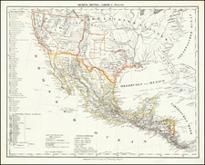
A fine example of HH Lloyd's scarce double page map of this portion of the Transmississippi West, centered on the Rocky Mountains. Tremendous detail throughout, too much early information to describe in detail. Includes counties, towns, railroads, mountains, rivers, explorer routes, US Mail Route, Indian lands and a host of other details. HH Lloyd never did issue his Atlas of the United States, but portion appeared in Warner & Beers Atlases during the 1870s. This map, for reasons unknown, was very rarely included. A bright fresh example of this sought after map. Minor centerfold split at bottom. This is the first time we have ever seen the map dated.
![[Montana, Wyoming, Dakota, Upper Missouri River] Amer. Sep. No. 40. Partie des Etats Unis](https://storage.googleapis.com/raremaps/img/small/93546.jpg)
![[ Colorado Atlas -- Presentation Copy ] Geological and Geographical Atlas of Colorado and Portions of Adjacent Territory](https://storage.googleapis.com/raremaps/img/small/101702.jpg)