
This item has been sold, but you can enter your email address to be notified if another example becomes available.


|
||

|

|
|

|
Stock# 91476
Description
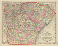
Detailed map of a large portion of the Carolinas, showing counties, towns, rivers, roads, mountains, bridges, lakes, post offices, court houses, and a host of other information.
The Society for the Diffusion of Useful Knowledge was active from the 1830s through the 1860s and published some of the best regional maps of the era.
![The State of North Carolina from the best Authorities [manuscript annotations]](https://storage.googleapis.com/raremaps/img/small/101026.jpg)
![[Port Lucie/Indian River to Cape Hatteras] East Coast of North America from the U.S. Coast Survey and the most recent authorities. Sheet V. . . . 1870](https://storage.googleapis.com/raremaps/img/small/90697.jpg)
![[ North Carolina ] Neueste Karte von Nord Carolina mit seinen Canaelen, Strassen, Eisenbahnen, Entfernung . . . .1845](https://storage.googleapis.com/raremaps/img/small/89079.jpg)