|
||

|

|
|

|
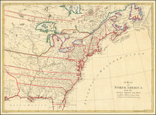
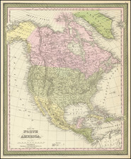
Rare (Unrecorded?) map of North America, first published in Paris by Pierre Bourgoin in 1743 and later revised after American Independence, in order to illustrate mountain ranges in North America.
This is the second state of the map is revised to to depict the mountain ranges of North America, and includes an expanded title, which translates as:
Map of North America With the Direction of the First Ranges of Mountains, for the Theory of Their Configurations Represented on a Map
One of the most striking features of the map is the depiction of the various mountain ranges that crisscross the continent. The map includes detailed information on the direction and orientation of these mountain ranges, including the Appalachian Mountains in the east and an early/primitive attempt to depict the Rocky Mountains in the west.
Depicts North America and the West Indies with a good amount of detail except in the west, which is mostly blank and labeled Quivira with the coastline ending at N'lle Albion.
Among the most interesting features of the map is a section identified as "Cotes decouvertes par Midelton en 1742," a reference to the discoveries of Christopher Middleton.
Christopher Middleton was an English naval officer and navigator. In 1741, Middleton was appointed to an expedition to explore the North American Arctic regions aboard the HMS Furnace, accompanied by a smaller vessel, that he purchased HMS Discovery under the command of Commander William Moor. The expedition sailed in May 1741 to Hudson Bay, in search of a Northwest Passage. Middleton spent the winter at Churchill, Manitoba. He then proceeded north into Roes Welcome Sound and discovered Wager Inlet, where he was iced in for three weeks. At the head of the sound he was blocked by ice and named the place Repulse Bay. He returned to England in 1742, where he was presented with the Copley Medal by the Royal Society, and where he presented a paper on "The extraordinary degrees and surprising effects of Cold in Hudson's Bay".
A fascinating note regarding the "suspect" discoveries of Admiral De Font reads:
Dans cette partie en avoit nuse les pretendues decouvertes de Amiral Font la relation en ayant ete trouve suspected par pluseures Auteurs on na pas cru deoire les mettre dans cette carte, dans la Mappemonde elles sont pointeas en attendant la verification.
(In this part, the pretended discoveries of Admiral De Font have been shown. The reports of these discoveries was found to have been suspect by several authors. They have not been included on this map, but on the world map are shown, subject to verification).
Rarity
Both editions of the map are rare.
This is the first example of the "Mountain Ranges" state of the map we have seen and may be previously unrecorded.
![(North America) ФИЗИЧЕСКАЯ КАРТА СEВЕРНОЙ АМЕРИКИ. [Physical Map of North America]](https://storage.googleapis.com/raremaps/img/small/90262.jpg)