


|
||

|

|
|

|
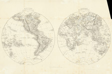
Fine mid-18th century double-hemisphere map of the world, showing the known continents at the time.
Europe, Asia, and Africa are well-delimited, but parts of North America remain as yet undiscovered, particularly in the Pacific Northwest. Australia is roughly delimited, with no delimitation between Australia, Tasmania, and New Zealand.
The text around the map describes the vast expanses of water around the globe. This focused treatment is unusual and is rarely seen with such maps.
This map was published circa 1767 in Paris by Jean Baptiste Louis Clouet.
Jean-Baptiste Louis Clouet (1730-ca. 1790) was a mapmaker with premises in both Paris and Cadiz. He was eventually named Royal Geographer of the Academie des Sciences de Rouen. Although he made several lavish wall maps, he is best known for Geographie Moderne (1776-93).
![[World] Air France](https://storage.googleapis.com/raremaps/img/small/67997.jpg)
![Western Hemisphere [and] Eastern Hemisphere](https://storage.googleapis.com/raremaps/img/small/90387.jpg)


![World [Rand, McNally & Company's Indexed Atlas of the World]](https://storage.googleapis.com/raremaps/img/small/100314.jpg)