


|
||

|

|
|

|
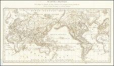
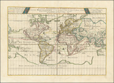
Illustrating the Major Commercial Sea Routes of the 17th Century
Finely colored example of Pierre Du Val's scarce 17th Century map of the World, illustrating the most important world trade routes during the middle of the 17th Century.
Du Val's map is constructed on a plane projection and illustrates the scientific approach to cartography then being championed by the French, free of the embellishments then in favor in the Netherlands. The map shows the World as known in the middle of the 17th Century, including many of the great cartographic myths of the period, including
- The Island of California
- Terre de Iesso, extending nearly to America
- The Straits of Anian
- The Northwest Passage
- The Unknown Southern Continent and incomplete mapping of Australia and New Zealand
- Narrow Strait of Magellan, Strait of LeMaire and Brower's Passage, between South America and the mythical Antarctic Coastline.
The map identifies the routes to and from the "Indies Occidentales" and "Indes Orientales", with small sailing ships shown on each route. As noted by Shirley, the routes illustrated are those used by French and English ships, rather than the more southerly routes across the Indian Ocean, and then to the north, preferred by the Dutch.
Du Val's map is perhaps most noteworthy for its fascinating depiction of "Terres Ant-Arctiques dites Australes et Magellaniques et Inconnues" retaining much of the mythical information that was more common on 16th Century maps, including places popularized by Marco Polo, such as the Kingdoms of Psitac (short for Psitacorum, the Land of Parrots), Beach, Lucac and Maletur (the Kingdom of Malaiur or Malays, which was placed by Marco Polo at the Southeast end of the Malay Peninsula).
Marked on the outlines of New Holland are the names of the coasts discovered by the Dutch. Du Val was at the time one of the proponents of a pre-1606 discovery of Australia by the French. On one of his other world maps of the period, he adds the following annotation on the incomplete Australian Continent: "ou l'an 1504 aborda Ie nomme GonneviIle qui en ramen a en Normandie Essonier [sic], fils du Roy d'Arosca' (where in the year 1504 landed Gonneville who brought back from there Essonier, son of King Arosca). While not specifically mentioned Gonneville, Du Val's map seems to have been influenced by the then current story of the French discoveries in the Southern Hemisphere by an explorer named Gonneville in 1504. The French explorer Captain Binot Paulmyer de Gonneville claimed to have discovered the southern continent in 1504. As noted by Howard Fry in Alexander Dalrymple and the Expansion of British Trade,
Gonneville had left Normandy in command of the Espoir in 1503, and after visiting the Canaries and Cape Verde, he had apparently crossed the Equator on a south-southwesterly heading, until he had been driven off course by a violent gale when in the latitude of the Cape of Good Hope. In January, 1504, he had then sighted land, where for the following six months he and his crew had lived on friendly terms with the natives, one of whom accompanied them on their return voyage. This was Esomeric, the son of a local ruler. Back in the English Channel, the Frenchmen had been attacked by an English pirate, and had lost their ship and papers. Many of the crew, however, survived, including Esomeric, and in an effort to get redress from the English, Gonneville made a statement to the naval authorities, an authenticated copy of which survived. The memory of this voyage remained alive, but the document gave no clue as to where this discovery was to be placed, and later interpretations were to include South America, Madagascar and even Australasia, to the south of the Moluccas.
Du Val was then serving as Royal Geographer to the King of France and his maps were of great commercial and geopolitical importance.
Rarity
The map is scarce.
The popular misconception of California as an island can be found on European maps from the sixteenth through the eighteenth centuries. From its first portrayal on a printed map by Diego Gutiérrez, in 1562, California was shown as part of North America by mapmakers, including Gerardus Mercator and Abraham Ortelius. In the 1620s, however, it began to appear as an island in several sources. While most of these show the equivalent of the modern state of California separated from the continent, others, like a manuscript chart by Joao Teixeira Albernaz I (ca. 1632) now in the collection of the National Library of Brasil shows the entire western half of North Americas as an island.
The myth of California as an island was most likely the result of the travel account of Sebastian Vizcaino, who had been sent north up the shore of California in 1602. A Carmelite friar, Fray Antonio de la Ascensión, accompanied him. Ascension described the land as an island and around 1620 sketched maps to that effect. Normally, this information would have been reviewed and locked in the Spanish repository, the Casa de la Contratación. However, the manuscript maps were intercepted in the Atlantic by the Dutch, who took them to Amsterdam where they began to circulate. Ascensión also published descriptions of the insular geography in Juan Torquemada’s Monarquia Indiana (1613) (with the island details curtailed somewhat) and in his own Relación breve of ca. 1620.
The first known maps to show California as an island were on the title pages of Antonio de Herrera’s Descripción de las Indias Occidentales (1622) and Jacob le Maire's Spieghel Der Australische Navigatie (1622). Two early examples of larger maps are those by Abraham Goos (1624) and another by Henry Briggs, which was included in Samuel Purchas’ Hakluytus Posthumus or Purchas his Pilgrimes (1625). In addition to Briggs and Goos, prominent practitioners like Jan Jansson and Nicolas Sanson adopted the new island and the practice became commonplace. John Speed’s map (1626-7), based on Briggs’ work, is well known for being one of the first to depict an insular California.
The island of California became a fixture on mid- and late-seventeenth century maps. The island suggested possible links to the Northwest Passage, with rivers in the North American interior supposedly connecting to the sea between California and the mainland. Furthermore, Francis Drake had landed in northern California on his circumnavigation (1577-80) and an insular California suggested that Spanish power in the area could be questioned.
Not everyone was convinced, however. Father Eusebio Kino, after extensive travels in what is now California, Arizona, and northern Mexico concluded that the island was actually a peninsula and published a map refuting the claim (Paris, 1705). Another skeptic was Guillaume De L’Isle. In 1700, De L’Isle discussed “whether California is an Island or a part of the continent” with J. D. Cassini; the letter was published in 1715. After reviewing all the literature available to him in Paris, De L’Isle concluded that the evidence supporting an insular California was not trustworthy. He also cited more recent explorations by the Jesuits (including Kino) that disproved the island theory. Later, in his map of 1722 (Carte d’Amerique dressee pour l’usage du Roy), De L’Isle would abandon the island theory entirely.
Despite Kino’s and De L’Isle’s work, California as an island remained common on maps until the mid-eighteenth century. De L’Isle’s son-in-law, Philippe Buache, for example, remained an adherent of the island depiction for some time. Another believer was Herman Moll, who reported that California was unequivocally an island, for he had had sailors in his offices that claimed to have circumnavigated it. In the face of such skepticism, the King of Spain, Ferdinand VII, had to issue a decree in 1747 proclaiming California to be a peninsula connected to North America; the geographic chimera, no matter how appealing, was not to be suffered any longer, although a few final maps were printed with the lingering island.
Pierre Duval (1618-1683) was a French geographer, cartographer, and publisher who worked in Abbeville and Paris during the seventeenth century. He was born in the former city, in northeast France, before moving to Paris. Duval was the nephew of the famous cartographer Nicolas Sanson, from whom he learned the mapmaker's art and skills. Both men worked at the royal court, having followed the royal request for artists to relocate to Paris. In addition to numerous maps and atlases, Du Val's opus also includes geography texts. He held the title of geographe ordinaire du roi from 1650 and died in 1683, when his wife and daughters took over his business.