|
||

|

|
|

|
Louisiana Purchase Map -- Texas in West Florida?
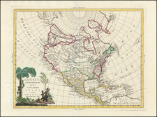
Scarce map of America with a large inset of the North Polar Regions, published in Weimar in 1804.
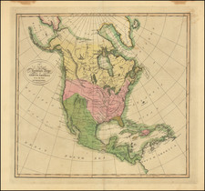
First published in 1800, the map has been significantly revised, most notably to illustrate the recent Louisiana Purchase, albeit quite curiously so.
The map provides a definitive (if ultimately inaccurate) picture of the mountain ranges in America, with the depiction of the mountains in California and the American West particularly fanciful, most notably the range which would separate California from Oregon. Remnants of an even earlier and stranger set of mountains can be seen to the right of the "C" in California.
Texas is shown as part of West Florida with the settlement of Texas named. The lower left of the map has a large inset showing the discoveries of Cook, Hearne, Vancouver and Mackenzie in Alaska and the Arctic regions.
The Northwestern part of the map is also completely revised, reflecting the knowledge of the Hudson's Bay Company and contemporary maps by Arrowsmith and others. The significant revisions can be seen by comparing this map to the 1800 edition: https://www.raremaps.com/gallery/detail/52206
![[United States Independence After The Revolution] A New Map of North America, with the West India Islands, Divided according to the Preliminary Articles of Peace, Signed at Versailles, 20 Jan. 1783, wherein are particularly Distinguished The United States, and the Several Provinces, Governments &ca, which Compose the British Dominions . . . 1783](https://storage.googleapis.com/raremaps/img/small/70734.jpg)