The item illustrated and described below is sold, but we
have another example in stock. To view the example which
is currently being offered for sale, click the
"View Details" button below.


|
||

|

|
|

|
Stock# 91343
Description
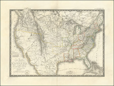
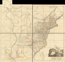
With Pencil Notes Projecting Transcontinental Railroad Routes
Highly detailed map of the United States, illustrating a number of the transitional Trans-Mississippi West territorial boundaries shortly after the end of the Civil War.
The map provides the Territorial configurations of 1861, on the eve of the Civil War, including:
- Proposed Arizona Territory below New Mexico (the so-called Baylor Line)
- Newly created Nevada Territory in its first configuration (before being expanded east to reduce the size of Utah)
- Colorado Territory
- Nebraska Territory including all of Montana and Wyoming -- a likely error, as the region was then part of Dakota Territory.
- Washington Territory wrapped around the new state of Oregon
Condition Description
foxing. Pencil notes adding in the transcontinental railroad routes.