


|
||

|

|
|

|
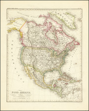
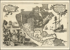
Highly detailed map of North America, published by Meyer.
The map shows Russian America, pre-Gadsden US-Mexico border and other early interesting territorial features, including large representations of:
- Oregon Territory (including Washington and Idaho)
- Utah Territory (including Nevada)
- New Mexico Territory (including Arizona)
- Missouri Territory (including Montana, Wyoming, Colorado, the Dakotas and Nebraska)
- Indian Territory (including Coloado and Kansas)
- Oversized Minnesota Territory
Joseph Meyer (1796-1856) was a German publisher who released Meyers Konversations-Lexikon, a German-language encyclopedia in print from 1839 to 1984. Meyer was born in Gotha and educated as a merchant in Frankfurt, an important city in the book trade. He traveled in London in 1816 and was back in German in 1820, where he began to invest in textiles and railways. He opened his publishing operation, Bibliographisches Institut, in 1826. His publications each had a serial number, a new innovation at the time. He was best known for his atlases and the Meyers Universum (1833-1861), which featured steel-engravings of the world. The Universum stretched to 17 volumes in 12 languages and was subscribed to by 80,000 people all over Europe. Thanks to his publishing success, Meyer moved the Institut from Gotha to Hildburghausen in 1828. Meyer died in the latter city in 1856.
![(North America) ПОЛИТИЧЕСКАЯ КАРТА СЕВЕРНОЙ АМЕРИКИ. [Political Map of North America]](https://storage.googleapis.com/raremaps/img/small/90261.jpg)