This item has been sold, but you can enter your email address to be notified if another example becomes available.


|
||

|

|
|

|
Stock# 91312
Description
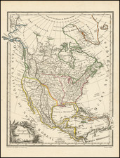
Interesting map of North America, with British possessions outlined in red, American in green, Spanish in yellow, and Russian in blue.
Russian America reaches south to the 55th parallel. This map shows the New Hanover to American control, despite simultaneous British claims. Spanish possessions reflect the results of the Adams-Onis Treaty, with Florida under American control and Mexican territory reaching as far north as the 42nd parallel and east as the Sabine River. The Red River Colony, west of Lake Superior and south of Lake Winnipegosis, including parts of present-day North Dakota, Minnesota, Manitoba, and Ontario, is shown as British territory.
Condition Description
Discoloration and text offsetting, most prominent in left half.
![Charte von Nord-America Prag 1818 [Rare Alaska Inset Map]](https://storage.googleapis.com/raremaps/img/small/72184.jpg)
![Tabula Terre Nove [The Admiral's Map]](https://storage.googleapis.com/raremaps/img/small/81714.jpg)
![[Unusual Italian Immigrant Communities shown!] America Settentrionale, Centrale e Meridionale -- Carta Dimostrativa Delle Ambasciate, Legazioni, Consolati (Con Le Risettive Circoscrizioni Territoriali), Camere Di Commercio, Agenzie Commerciali, Stazion Enotecniche, Uffici Postali, Ospedali, Scuole Governative e Sussidiate All'Estero](https://storage.googleapis.com/raremaps/img/small/86098.jpg)