|
||

|

|
|

|
Stock# 91302
Description
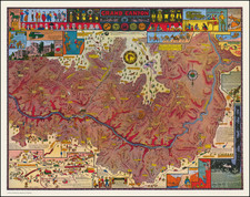
Scarce pictorial map of the area around Big Horn Camp, near Lake Arrowhead, California, drawn by J.T. Hale.
The map is centered on the Big Horn, then operated by the Los Angeles Area Council of the Boy Scouts of America, with Crestline, Cedar Glen, Rim Forest, Sky Forest, Running Springs, Snow Valley and other neighboring communities shown.
Signs leading away from camp point toward Fisherman's Creek, Deep Creek, Ceder Creek and Shake Creek.
![[ Bavarian Alps ] Deutsche Alpenpost Lindau -- Garmisch-Partenkirchen](https://storage.googleapis.com/raremaps/img/small/98061.jpg)