|
||

|

|
|

|
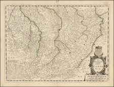
The Earliest Known Map Based Upon A Systematic Field Survey -- Likely by Marin Waldseemuller Himself (Hessler)
"Of Great Interest In the History of Map Printing" (Woodward, 50)
Fine example of the earliest map printed in more than two colors. (Skelton) and drawn from "the first known systematic field survey" (Hessler).
Oriented with south at the top and centered on the the course of the Moselle River and its tributaries from the area near Remiremont in the north to Trier in the south. The map details the homeland Waldseemuller. This map of the Duchy of Upper Lorraine was produced by Matthias Ringmann and Martin Waldseemuller for their 1513 edition of Ptolemy's Geographia, the first edition of Ptolemy to substantially modernize the ancient text and included three maps based on contemporaneous surveys.
The map "is particularly interesting in that it was based on the first known systematic field survey" (Hessler), most probably executed by Waldseemuller himself.
Among Waldseemuller's maps, this is the only one printed in more than one color. Published to honer honor of Rene II, Duke of Lorraine and King of Jerusalem whose patronage made possible the group of scholars, known as the Gymnasium Vosgensis, to which Waldseemuller and Ringmann belonged. The map displays in detail all of Rene's II's Duchy, including the location of the Gymnasium at St. Die (S. Deoditine on the map.) Hessler notes its remarkable accuracy, as well as its decorative quality, with the arms of the Duchy of Lorraine and the arms of 17 counts and barons associated with the region.
The map also includes notations indicating the locations of important resources: salt, lead, "lasurum" (possibly lapis lazuli) and (slightly more farfetched) pearls.
Rarity
The map is scarce. However, because of its historical importance, the map seems to be relatively rare on the market.
We note only 3 dealer catalog entries in the past 40 years (Arkway 1983; Arkway 1983; Martayan Lan 2015).
Martin Waldseemüller (c. 1475-1520) was a sixteenth-century cosmographer best known for his 1507 world map in twelve sheets, the earliest surviving map to include the name “America.” He was an influential mapmaker during his time whose work affected many of his contemporaries and successors. Waldseemüller was born near Freiburg, in what is now southwestern Germany. His family moved to Freiburg proper when he was young and he attended university in the city beginning in 1490.
Waldseemüller gathered information about the New World discoveries and geography from St.-Dié des Vosges in Lorraine, where he was a professor of cosmography under the patronage of René II, Duke of Lorraine. He was a member of an intellectual circle who produced work from the St.-Dié Press. However, the press failed when the Duke died, and Waldseemüller moved to Strasbourg.
He is best known for the 1507 map and another world projection, the Carta Marina published in 1516. He also published an edition of Ptolemy in 1513, in collaboration with Johann Schott, a friend from Freiburg and St.-Dié. Besides his innovative use of the toponym “America”, Waldseemüller was the first to create such a large printed world map, the author of the earliest known printed globe gores, the first to create a published collection of modern maps, and one of the first to create maps from ground measurements. He was knowledgeable in surveying methods and designed a quadrant and other instruments. He returned to St.-Dié late in life as canon, although he continued to return to Strasbourg for work and for carnival. He died in St.-Dié in 1520.
Waldseemuller is generally credited with having named the continent of America, based upon the then current belief that Amerigo Vespucci had been the first modern explorer to reach the continent of America in 1497, during the first of four expeditions to America which were then credited to Vespucci between 1497 and 1504. The report which described the 1497 expedition is now generally believed to be a forgery. Later in his career, Waldseemüller elected not to use the toponym for the continents, preferring to leave them unnamed. However, the name had been taken up by his contemporaries, in large part due to the influential nature of Waldseemüller’s earlier works.
![(Basel, Switzerland and southern Germany) Basiliensis Territorii Descriptio Nova [with] Circulus Sive Liga Suevia Vulgo Schwabische Kraiss](https://storage.googleapis.com/raremaps/img/small/82573.jpg)
![[Metz] Le Vray Pourtraict de la Ville de Mets](https://storage.googleapis.com/raremaps/img/small/74161.jpg)