


|
||

|

|
|

|
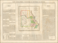
French edition Carey & Lea's map of Missouri, one of the earliest separate maps of Missouri. Only 16 counties are shown. The Osage line is still present in the west. The surrounding text includes a description of Missouri, including rivers, mines, county information, religion, commerce Gouverment and history and names Missouri's first Governor, Alexander McNair. A wonderful early map of Missouri.
Jean Alexandre Buchon (1791-1849) was a French scholar and historian. Born as the French Revolution raged, Buchon was dedicated to recovering France’s history in order to help the country heal and grow. He gathered French stories and published them as part of Collection des chroniques nationales franciases ecrites en langue vulgaire, du XIe au XVIe siècle (4 vols, 1824-1829). He also compiled and published an exploration collection and several histories, particularly about medieval France.
For geography, his most important contribution was publication of the French edition of Carey & Lea’s American Atlas in 1825. Each page of the atlas includes highly detailed text about the state or territory depicted, as well as a map of the area. The French edition is generally considered in high regard as compared to other editions, as it has quality paper and superior engraving.


![Factors of Prosperity in the Rock Island-Frisco States of America [cover title]](https://storage.googleapis.com/raremaps/img/small/94604.jpg)
![[ The Old Northwest Territory ] Il Paese De Selvaggi Outagamiani, Mascoutensi Illinesi E parte Delle VI Naxioni](https://storage.googleapis.com/raremaps/img/small/75927.jpg)