


|
||

|

|
|

|
Stock# 91155
Description
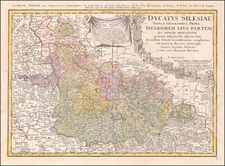
Fine original antique map of the region of Silesia, in modern-day Poland, by the German cartographer David Funcke.
Published around the turn of the 18th century, this map shows a detailed look at western Poland. The map centers of Wroclaw, termed Breslaw (Breslau) on the map. The course of the Oder River goes through the region. Individual sub-regions are shown, as are many small towns and cities.
Silesia was part of Poland at the start of the 18th century, but it would become Prussian during the War of the Austrian Succession, and eventually part of the German Empire in 1871. It would rejoin Poland following the First World War.
Condition Description
Dampstaining and soiling to margins.
![(Second World War - Holocaust) Miejsca walk i męczeństwa narodu Polskiego na terenie woj. Opolskiego w latach 1920-1945 [Places of fights and martyrdom of the Polish nation in the province Opolski in the years 1920-1945]](https://storage.googleapis.com/raremaps/img/small/82707.jpg)
![[ Holy Roman Empire ] A New Map of the German Empire, and the Neighbouring States with their Principal Post Roads, Originally Published by the Royal Academy of Berlin . . . 1788](https://storage.googleapis.com/raremaps/img/small/102913.jpg)