|
||

|

|
|

|
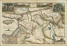
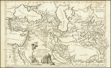
Rare Separately-Published Map of the Roman Empire.
A fine and rare example of Jacob Honervogt's map of the Roman Empire, published in Paris in about 1630.
Honervogt's map is drawn from the map of Abraham Ortelius, but relies on a more dramatic depiction of the ocean, similar to the style of Jodocus Hondius in his earliest maps.
The map is centered on the Mediterranean and shows the Empire at its greatest extent, stretching from England to the Middle East. The map includes a number of decorative cartouches, including one in the lower right showing the genealogy of the first seven Kings of Rome. The map includes insets of a portrait of Romulus and a personification of Rome. The map names cities, rivers, mountain ranges, and much more throughout.
Honervogt's maps are generally copied from other sources, but his output was very limited and generally separately published, leading to the extreme rarity of his maps today. Engraving differences can be used to identify Honervogt's editions of maps, for example, on this map the sea has a dramatic zig-zag pattern. This can be easily contrasted with Ortelius's stippled ocean.
States
We note two states of this map.
- "Iacques Honeruogt exc" at the end of the text in the lower left cartouche.
- Lacking the above imprint.
Rarity
Honervogt's maps are of the utmost rarity, primarily due to their separately-published nature.
We trace only one institutional record for this map (at the BNF, the only Honervogt map they hold) and one auction record for the map.
Honervogt was a German born engraver, who moved to Paris in about 1608.
Honervogt had established a map shop in Paris by 1624. Sometime after 1654, he took on Gerard Jollain as a partner. Jollain continued the business after Honervogt's death.
![Turquie en Asie [Shows Cyprus]](https://storage.googleapis.com/raremaps/img/small/87678.jpg)