


|
||

|

|
|

|
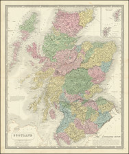
Pierre Mariette's map of Scotland, published in Paris in 1665, is notable for being one of the first detailed maps of Scotland, drawn from some of the earliest available Scottish sources, including Timothy Pont and Robert Gordon of Straloch.
The map is drawn from Joannes Blaeu's second map of Scotland, based upon the information which Blaeu was provided by Robert Gordon of Straloch. The map credits both Gordon and Timothy Pont, whose work on mapping Scotland preceded Gordon.
Timothy Pont (1565-1614) was a Scottish clergyman and cartographer who lived in the late 16th and early 17th centuries. He is considered one of the most important figures in the history of Scottish cartography and among its earliest mapmakers, having travelled through Scotland making maps in the 1580s and 1590s. Pont is credited with producing the first comprehensive mapping of Scotland
Robert Gordon of Straloch (1580-1661) was a Scottish a Scottish cartographer, noted as a poet, mathematician, antiquary, and geographer, and for his collection of music for the lute. In 1641, Charles I wrote a letter, in which he urged Gordon to complete the publication of an atlas of Scotland, which had been begun by Timothy Pont. By two Acts of the Scottish Parliament he was exempted from any form of military service, while the General Assembly of the Church of Scotland published a request to the clergy, to make contributions to the mapping process. Gordon's work was completed in 1648 and was published by Joan Blaeu of Amsterdam, under the title of Theatrum Scotiae, the first comprehensive delineation of Scotland made from actual survey and measurement.
![[ Scotland ] Regnum Scotia, seu pars Septent: Magnae Britanniae, divisa in Scotiam Septent: et Astralem, porro autem in Comit: Rossiam Moraviam, Argatheliam, et Gallovidiam,; Vicencomit: Banfam et Marriam; Praefect: Laudoniam, Renfroviam et Anadiam; una cum Insulis Ebuda . . .](https://storage.googleapis.com/raremaps/img/small/102857.jpg)
![[Scotland] Scotia Parte Settentrionale . . . [and] Scotia Partie Meridionale . . .](https://storage.googleapis.com/raremaps/img/small/35543.jpg)
![[ Scotland ] L'Escosse Royaume en ses deux Princpales Parties . . . 1665](https://storage.googleapis.com/raremaps/img/small/102859.jpg)