|
||

|

|
|

|
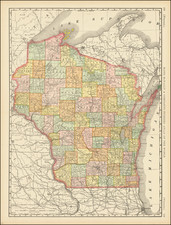
First General Land Office Survey of Wisconsin and Eastern Minnesotat
Antique map of Wisconsin and part of Minnesota Territory, produced by George B. Sargent, Surveyor General of the Dubuque Office, on October 21, 1852.
This is apparently the first state of a map which would be issued for several years, with annual updates showing the progress of the the surveys in Wisconsin and eastern Minnesota.
This early state lays out for the first time a number of treaty and boundary lines which make up the Wisconsin. One noteworthy feature is that this is the only map that shows two boundary lines running south from St. Louis River near the west end of Lake Superior, showing a different boundary for the division between Minnesota and Wisconsin and the October 4th 1842 Treaty Line. In the next state of the map, the course of the St. Louis River is significantly changed and the treaty line removed.
The area of Minnesota south of the confluence of the Mississippi River and the St. Peters River is noteworthy, as it shows only the hydrographical features, which would be removed in all subsequent states of this map from the October 21, 1853 state onward.
The map shows the reservations of the Oneida Indians, but the Reservation of the Brothertown Indians and Stockbridge Indians are only shown in outline, without names.
Fort Snelling and the Falls of St. Anthony are shown, but the city of St. Paul would not be added until the following year.
Fort Gaines and Prairie du Chien are also noted.
The General Land Office (GLO) refers to the independent agency in the United States that was in charge of public domain lands. Created in 1812, it assumed the responsibilities for public domain lands from the United States Department of the Treasury. The Treasury had overseen the survey of the Northwest Territory, but as more area was added to the United States, a new agency was necessary to survey the new lands.
Eventually, the GLO would be responsible for the surveying, platting, and sale of the majority of the land west of the Mississippi, with the exception of Texas. When the Secretary of the Interior was created in 1849, the GLO was placed under its authority. Until the creation of the Forest Service in 1905, the GLO also managed forest lands that had been removed from public domain. In additional to managing the fees and sales of land, the GLO produced maps and plans of the areas and plots they surveyed. In 1946, the GLO merged with the United States Grazing Service to become the Bureau of Land Management.
![(Rochester, Minnesota) [Early letter -- Mary Hannak?]](https://storage.googleapis.com/raremaps/img/small/31788.jpg)