|
||

|

|
|

|
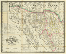
First Appearance of California's Mexican Rancho/Land Grants Confirmed by the United States
Nice example of one of the earliest obtainable official maps of California, published by the General Land Office.
Beginning in 1854, the United States General Land Office began publishing an annual "Map of the Public Surveys." The first edition of the map was oriented with east at the top, with subsequent editions beginning in 1854 oriented with north at the top. Beginning in 1863, the map was expanded to include California and Nevada, with the size remaining the same.
Signed by John Coffey Hays, the US Surveyor General for California, the maps tracked the progress of the US Government Surveys in California, as well as recording the private land grants (Mexican Ranchos) which had been confirmed through the judicial process established following the United States annexation of California from Mexico under the Treaty of Guadalupe Hidalgo. Remarkably, but 1856, only 4 land grants had been confirmed. This is the first state of the map to include confirmation information
The General Land Office (GLO) refers to the independent agency in the United States that was in charge of public domain lands. Created in 1812, it assumed the responsibilities for public domain lands from the United States Department of the Treasury. The Treasury had overseen the survey of the Northwest Territory, but as more area was added to the United States, a new agency was necessary to survey the new lands.
Eventually, the GLO would be responsible for the surveying, platting, and sale of the majority of the land west of the Mississippi, with the exception of Texas. When the Secretary of the Interior was created in 1849, the GLO was placed under its authority. Until the creation of the Forest Service in 1905, the GLO also managed forest lands that had been removed from public domain. In additional to managing the fees and sales of land, the GLO produced maps and plans of the areas and plots they surveyed. In 1946, the GLO merged with the United States Grazing Service to become the Bureau of Land Management.
![(Bird's-Eye View of California) San Francisco Invites You [cover title]](https://storage.googleapis.com/raremaps/img/small/92552.jpg)