|
||

|

|
|

|
Rare separately issued map of Indian Territory and Oklahoma Territory, shortly after the creation of Oklahoma Territory from the western part of Indian Territory in 1890.
The map shows the borders of these two territories in 1892, as well as location of Reservations, railroad lines, roads, towns, rivers, lakes, mines and other geographical features. It also includes the location of military forts and other points of interest.
Oklahoma Territory was created in 1890, when the United States Congress passed the Organic Act. This act divided the Unassigned Lands (a large area of land in central Oklahoma that was not yet part of any state or territory) into two territories: Oklahoma Territory and Indian Territory. The Organic Act also established a territorial government, with a governor, a legislature, and a judicial system, giving the people of the territory a greater degree of autonomy and self-government.
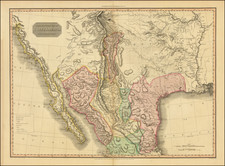
Oklahoma occupies only small section of the map, which contains an early appearance of Oklahoma City on a printed map. The map graphically shows the situation of Native American tribes after forced removal from their homelands to the Indian Territory of eastern Oklahoma.
Includes the site of We-Wo-Ka (“barking waters”) District, where the Black Seminoles eventually relocated after leaving the protection of Fort Gibson. They founded an all-Black community on the site of the present-day town of Wewoka, now the home of the Seminole Nation of Oklahoma. Of Texas interest is the much disputed Greer County, not shown as part of Texas and bearing the designation “Unassigned Land.” Texas claimed the area, but the Supreme Court denied Texas’ claim in 1896. See Handbook of Texas Online: Greer County.
States of the Map and Rarity
This is apparently the first state of the map with this title, which was issued until at least 1895.
OCLC locates 2 examples of the 1892 (Southeastern Oklahoma State University and Princeton.
Rand McNally & Co. is a large American map and navigation company best known for its annual atlases. The company got its start in 1856, when William Rand opened a print shop in Chicago. He was joined in 1858 by a new employee, Andrew McNally. Together, the men established their namesake company in 1868. Originally, the company was intended to print the tickets and timetables for the trains running to and through Chicago; their first railway guide was published in 1869.
By 1870, they had shifted from just printing to publishing directories, travel guides, and newspapers. Their first map appeared in 1872 in a railway guide. The map was produced using a new wax engraving method, a cheaper process that gave the company an edge.
By 1880 Rand McNally had entered the education market with globes, wall maps, and geography texts for students. In 1923, Rand McNally published the first Goode’s World Atlas, named after its editor, Dr. J. Paul Goode. For generations afterward, this would be the standard classroom atlas.
In 1899, William Rand left the company, but McNally and his family remained, controlling the company for over a century. In 1904, they published their first road map intended for automobiles and by 1907 were publishing Photo-Auto Guides, which combined photography and mapping to help drivers. In 1924, they produced the Auto Chum, a precursor to their famous road atlases. Rand McNally would remain the leader in road maps and atlases throughout the twentieth century.
In 1937, Rand McNally opened its first store in New York City. Ever on the frontier of technology, Rand McNally pioneered the scribing process for printing tickets in 1958 and printed their first full-color road atlas in 1960. Arthur Robinson developed his now-famous projection of Rand McNally in 1969. By the 1980s, the company was exploring digital reproduction and digital databases of maps for truckers. In the 1990s, they lead the charge to develop trip-planning software and websites. Today, most of its products are available online or in a digital format, including maps for tablets and phones.

![(Native American Photograph) [Fox On The War Path (Ke-wuk-o-car-war-ry), a Pawnee man of Indian Territory]](https://storage.googleapis.com/raremaps/img/small/93109.jpg)