


|
||

|

|
|

|
The Only Example in Private Hands of the First State, per Bifolco and Ronca.
An Exceptional Example.
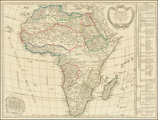
An outstandingly crisp and dark impression of Claudio Duchetti's 1579 map of Africa, one of the greatest separate maps of Africa from the 16th century.
The map shows the African continent and its islands in full, with extensions to the Arabian Peninsula, Middle East, and Southern Europe. The cartography derives from Giacomo Gastaldi's mural of Africa at the Ducal Palace of Piedmont by way of the 1562 Paolo Forlani map of the continent and represents the forefront of European knowledge regarding Africa in the late 16th century. The map was published as the Portuguese explorer Duarte Lopez was beginning his twelve years in the Congo, which would shortly be used to produce Antonio Pigafetta's important update to the geography of the continent.
The Nile is shown as sourced from two lakes, without the Mountains of the Moon. One of these lakes, the "Lago de Zembere," also sources the Zaire (Congo) River. Major East African ports are shown and named. Detail in the middle east is fine, with the twin islands of "Quessimi" and "Baharem" (i.e., Bahrain).
The map was published by Claudio Duchetti, a French-born mapmaker active between Venice and Rome between 1565 and his death in 1585. Following the death of Antonia Lafreri in 1577, he obtained the entirety of the Lafreri stock, and his firm rapidly grew. He published this Africa map in 1579, which Betz suggests was published in Rome given the decorative elements. Interestingly, this is the only map that Duchetti collaborated on with Henricus Honius (not to be confused with Henricus Hondius, of the following century). However, the map appears to possess a clear Dutch signature, with an ornate geometrical strapwork cartouche and angular, rather than rounded, mountains.
Cartographic Sources
Most researchers (including Bifolco and Ronca, and Betz) cite the 1563 Forlani and Camocio map of Africa as the likely source for Duchetti's edition of the work. However, we conclude that it is more likely that Duchetti drew directly from the 1562 Forlani map of the continent.
Several notable changes made on the 1563 map are absent here. Most importantly, the information from the Gastaldi map of Asia that Forlani and Camocio (the Maldives, Indian Peninsula, and Deserto de Tachalistan) incorporate is not present here. The decorative elements present also closely match the 1562 Forlani. However, perhaps the most definite proof that Duchetti drew from the 1562 map comes from the appearance of the tilde over the "o" in "Manicoga" (the Congo River), which disappears in the 1563 Forlani and Camocio.
There is still the possibility that Duchetti may have partially drawn from the 1563 Camocio and Forlani. Several typographical corrections appear to have been made on both maps, although it is possible that they were made independently. For example, the description of the location of Prester John's palace changes from a "more" (sea) to a "monte" mountain in both the 1563 and the Duchetti.
A Further Note on the Printing
The exceptional quality of this engraving is truly noteworthy. The blacks are so intense that they appear almost purple, while the depth of the coastlines gives the impression that the continent is emerging from the ocean. The cartouche also has a nearly three-dimensional effect. Such wide original margins are uncommon on a Lafreri School map. This map is a beautiful example of the Dutch engravers' ability to create high-quality, rarely preserved items. The map's dark impression, intricate engraving, and original margins make it an almost perfect representation of maps from that period.
States
The map is described by Bifolco and Ronca as existing in two states:
- With the imprint Claudio ducheto exc. Lanno. 1579.
- The imprint Petri de Nobilibus Formis added in the strapwork cartouche and in the lower right. This second state likely datie to immediately after Duchetti's death in 1585 and the subsequent re-acquisition of the plate by Petri de Nobilibus.
Rarity
The first state of this map is known in only one other example, at the Birmingham Public Library. The second state is known in only three examples.
Betz 19

![[Democratic Republic of the Congo] Congo Belge](https://storage.googleapis.com/raremaps/img/small/77991.jpg)