|
||

|

|
|

|
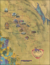
Unique Bay Area Topographical Map
Finely executed and extremely rare topographical map of the San Francisco Bay Area, from Santa Cruz to Napa and Tracy, published in San Francisco by Whitaker & Ray. Co.
This is one of the most interesting topographical style maps we have seen.
Details include towns, mountains, lakes, rivers, railroads, islands, etc. The present example also shows the counties in outline color.
Rarity
OCLC lists only one example of the 1907 issue, at the University of California Berkeley, and two of a 1909 edition (California State Library and UC Davis).
We offered and example of the map lacking the 7 in 1907 in 2017, which also did not include outlline color in the counties.
Whitaker & Ray Company was a prominent educational supply house and publishing company in San Francisco from approximately 1895 to around 1915. The company was originally established in 1869 by Andrew Whitaker and Don Ray as an agricultural brokerage in Galt, California.
The firm underwent significant changes after Whitaker's passing in April 1894. His son, James Whitaker, took over his father's share of the company, but most of the decision-making fell to Don Ray and his son John Ray. Under their leadership, the company shifted to publishing and educational supplies.
In 1895, the firm incorporated and expanded its operations by acquiring the educational supply division of the Bancroft Company. With it came the expertise of C. C. Adams and Charles M. Wiggin, who previously managed the educational department at Bancroft. Wiggin joined Whitaker and Ray permanently and contributed significantly to its growth.
Whitaker & Ray Company’s publishing endeavors began in 1896, with output growing significantly between 1899 and 1906. However, the 1906 earthquake and fire caused substantial damage to their premises at 723 Market Street. Despite this setback, by 1909, the company had relocated to a more central location at 779-760 Mission Street. Following Don Ray's passing around 1910, the company's name evolved to Whitaker and Ray-Wiggin Company, reflecting the enormous influence that Charles Wiggin had on the company’s later success. The company remained active until at least 1915.
![[ Baja California / Gulf of California ] Carta Esferica de las Costas y Golfo De Californias Llamado Mar De Cortes Que Comprende desde el Cabo Corrientes hasta el Puerto de San Diego Construida …. 1825](https://storage.googleapis.com/raremaps/img/small/102732.jpg)
![(California Gold Rush) Oregon and California in 1848 in Two Volumes [with:] Map of California, Oregon, Texas, and the Territories adjoining with Routes &c.](https://storage.googleapis.com/raremaps/img/small/82901.jpg)