|
||

|

|
|

|
Stock# 91033
Description
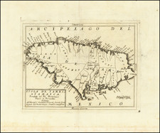
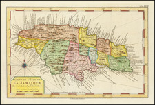
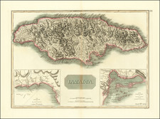
Finely crafted map of Jamaica, published in London by Carrington Bowles.
The map provides a remarkably detailed, locating towns, churches, forts, sugar works, gentlemen's seats, taverns, crawls, roads, parishes, barracks and other details. In addition to sugar works, the map locates "Pens Ginger Coffee & Indigo Settlements." Along the coastline there are a few soundings, safe anchorages and navigational hazards noted.
A large inset provides a plan of Port Royal that shows the infamous pirate stronghold both before and after the earthquake that destroyed much of the town in 1692.
Reference
Kapp #69