|
||

|

|
|

|
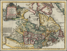
The First North American City Plan and the First Appearance of Montreal on a Printed Map (Kershaw)
Fine example of Ramusio's map of Montreal, the first printed plan of a town in North America.
Jacques Cartier, the great French explorer, visited the village of Hochelaga on the island of Montreal in 1535. The village was near a mountain the explorer named Mount Royal or Monte Real. His account was published in the third volume of Ramusio's Delle navigationi et viaggi in 1556.
The map includes many of the village's features as described by Cartier. The mythical large welcome is depicted in the clasping of hands by a Frenchman (presumably Cartier) and a native chief, and the advantage of two-story fortifications is demonstrated. The lodges within the fort are exceedingly symmetrical, but with each family unit indicated by a fire, they were probably intended to indicate that they were both single-family and multiple-family or extended family dwellings.
It is not clear who the Hochelagans were, although most likely either Huron or Iriquois. The village was gone by the time Champlain arrived.
Ramusio was the first to publish this map, which was copied by later authors in other editions.
States and Editions of the Map
There are two editions of the map. The first edition was published a single state in 1556, identifiable by the transparency of the smoke in the fire in front of the village and the more rounded nature of the trees. This plate was subsequently destroyed in a fire.
The second edition exists in two states, one published in 1565 and one in 1606. The first state has page numbers 446 and 446. In the second state, the page numbers are changed to 380 2 and 380 3. This second state of the second edition is accompanied by wormwood damage.
Giovanni Battista Ramusio (1485-1557) was an Italian geographer who worked within the Venetian Empire. His father had been a magistrate and he himself served as a civil servant to Venice. He served throughout Europe, allowing him to build up a network of informants and a collection of travel materials. He compiled this information into his enduring masterpiece, Navigationi et Viaggi, in 1550 (first volume) and 1556 (third volume). The second volume appeared after his death in 1559, as the original manuscript had been destroyed by a fire.