![[ Colorado ] By Rand McNally & Company](https://storage.googleapis.com/raremaps/img/small/88749.jpg)


|
||

|

|
|

|
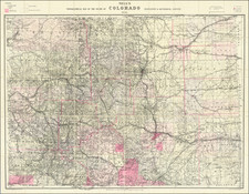
Finely executed map of Colorado, offering a detailed, representation of the state in the midst of expansion and change.
Colored by counties, the map outlines the borders of each with distinctive colors for easy differentiation. It is a comprehensive depiction, including details of township surveys, roads, railroads, and mountains, as well as rivers, railway stations, towns, and mining operations.
In the last quarter of the 19th Century, Colorado experienced significant growth, particularly in its southwestern region. The map brings this area into sharp focus, illustrating the San Juan mining regions around the towns of Silverton, Ouray and Telluride (here still called Folsom or Columbia). These and other boom towns of the time are shown, showing the profusion of both population and industry spurred by the silver rush. The network of roads and railways connecting these towns reveals how this remote region was made accessible, facilitating the transportation of goods and contributing to Colorado's economic development.
The period saw the formation of several new counties in Colorado, as indicated on the map. Bent County, split in 1874, created present-day Las Animas County. In 1876, Elbert and Lincoln counties were carved out from the eastern part of Douglas County and the southern part of Arapahoe County, respectively. Bent County was further divided in 1887 to create Prowers County, although this change is not represented on the 1883 map.
San Miguel County, home to the boom town of Telluride, was formed in 1883. This county was particularly important given its rich silver deposits, which attracted a significant influx of miners, investors, and settlers. The creation of these new counties and the infrastructure linking them underlines the rapid development that the state of Colorado underwent during this period.
In sum, the 1883 map of Colorado provides a visually rich and detailed representation of the state's geographical and socio-economic landscape at a time of significant transformation. The map serves as a historic document, capturing the growth of the region, the flourishing of the mining industry, and the creation of new counties to manage this growth effectively.
Rand McNally & Co. is a large American map and navigation company best known for its annual atlases. The company got its start in 1856, when William Rand opened a print shop in Chicago. He was joined in 1858 by a new employee, Andrew McNally. Together, the men established their namesake company in 1868. Originally, the company was intended to print the tickets and timetables for the trains running to and through Chicago; their first railway guide was published in 1869.
By 1870, they had shifted from just printing to publishing directories, travel guides, and newspapers. Their first map appeared in 1872 in a railway guide. The map was produced using a new wax engraving method, a cheaper process that gave the company an edge.
By 1880 Rand McNally had entered the education market with globes, wall maps, and geography texts for students. In 1923, Rand McNally published the first Goode’s World Atlas, named after its editor, Dr. J. Paul Goode. For generations afterward, this would be the standard classroom atlas.
In 1899, William Rand left the company, but McNally and his family remained, controlling the company for over a century. In 1904, they published their first road map intended for automobiles and by 1907 were publishing Photo-Auto Guides, which combined photography and mapping to help drivers. In 1924, they produced the Auto Chum, a precursor to their famous road atlases. Rand McNally would remain the leader in road maps and atlases throughout the twentieth century.
In 1937, Rand McNally opened its first store in New York City. Ever on the frontier of technology, Rand McNally pioneered the scribing process for printing tickets in 1958 and printed their first full-color road atlas in 1960. Arthur Robinson developed his now-famous projection of Rand McNally in 1969. By the 1980s, the company was exploring digital reproduction and digital databases of maps for truckers. In the 1990s, they lead the charge to develop trip-planning software and websites. Today, most of its products are available online or in a digital format, including maps for tablets and phones.
![Map of the Missouri Pacific and St. Louis, Iron Mountain and Southern Railway and Connections [Missouri Pacific Railway. St. Louis & All Points East Chair Cars Free Fast Mail Route]](https://storage.googleapis.com/raremaps/img/small/91606.jpg)

![[Aspen] Snowmass Village](https://storage.googleapis.com/raremaps/img/small/63539.jpg)