|
||

|

|
|

|
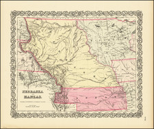
Territories of Colona and Shoshone
Fine example of Andriveau-Goujon's 2-sheet map of the United States.
Unlike later editions of the map, the Territory of Colona appears, predating the appearance of Colorado. Similarly, an oddly misprojected Idaho appears, but is called Shoshone. Massive Nebraska runs to the Canadian Border. Arizona is below New Mexico. Many early roads, forts and Indian Tribes noted in the west.
The map also shows a newly formed Nevada Territory, as well as an appearance of Arizona Territory below New Mexico Territory (which would be called the Baylor Line).
A highly desirable map and an essential item for Colorado, Idaho and Western collections.
Colona Territory
In early November, 1858, the citizens of the mining districts in Western Kansas decided to petition Congress to organize a new territory . On November 6, 1858 an election was held and Hiram J. Graham was chosen to represent the group in Washington. The name chosen for the new territory was Colona. On January 6, 1859, Schuyler Colfax introduced a bill in House of Representatives for the creation of Colona Territory. The bill died.
Thereafter, Graham persuaded Senator Green of Missouri to introduce a similar bill in the Senate on January 27, 1859. On 18 January Graham wrote from Washington:
On the sixth of November last I was elected delegate from Colona by the voters thereof, to urge upon Congress the propriety and necessity of granting us a territorial organization. I have no doubt this result will be attained so soon as the justice of our claims is understood . . .
In the meantime, after the Colfax bill died in the House, a decision was made to change the name to Jefferson Territory. Graham persuaded Alexander H. Stephens to introduce such a bill in the House on January 28, 1859. There was some objection to the name and Representative Grow (of Pennsylvania) suggested the name Osage Territory, but the House session ended without passage of the bill. The senate committee on territories presented an unfavorable report on the bill introduced by Senator Green and the report was accepted by the Senate. So attempts to establish Colona Territory or Jefferson Territory died in the second session of the 35th Congress.
Attempts to form a territory would continue until the creation of Colorado Territory on February 28, 1861.
Arizona Territory Below New Mexico Territory
Following the expansion of the New Mexico Territory in 1853, as a result of the Gadsden Purchase, several proposals for a division of the territory and the organization of a separate Territory of Arizona in the southern half of the territory were advanced as early as 1856.
The first proposal dates from a conference held in Tucson that convened on August 29, 1856. The conference issued a petition to the U.S. Congress, signed by 256 people, requesting organization of the territory and elected Nathan P. Cook as the territorial delegate to Congress. In January 1857, the bill for the organization of the territory was introduced into the House of Representatives, but the proposal was defeated.
In February 1858, the New Mexico territorial legislature adopted a resolution in favor of the creation of the Arizona territory, but with a north–south border along the 109th meridian. In April 1860, impatient for Congress to act, a convention of 31 delegates met in Tucson and adopted a constitution for a provisional territorial government of the area south of 34 degrees north. The delegates elected Dr. Lewis S. Owings as provisional governor.
At the outbreak of the Civil War, sentiment in the territory was in favor of the Confederacy. Territorial secession conventions were called at Mesilla and Tucson in March 1861 that adopted an ordinance of secession, established a provisional Arizona Territory with Owings as its governor, and petitioned the Confederate Congress for admission.
The Confederacy regarded the territory as a valuable route for possible access to the Pacific Ocean, with the specific intention of capturing California. In July 1861, a small Confederate force of Texans under the command of Lieutenant Colonel John R. Baylor assaulted Fort Fillmore at Mesilla in the eastern part of the territory. After the fort was abandoned by the Union garrison, Baylor's force cut off the fleeing Union troops and forced them to surrender. On August 1, Baylor issued a "Proclamation to the People of the Territory of Arizona", taking possession of the territory for the Confederacy, with Mesilla as the capital and himself as the governor. Baylor's subsequent dismantling of the existing Union forts in the territory left the white settlers at the mercy of the Apache, who quickly gained control of the area and forced many of the white settlers to seek refuge in Tucson.
On August 28, a convention met again in Tucson and declared that the territory formed the previous year was part of the Confederacy. Granville H. Oury was elected as delegate to the Confederate Congress. Oury drafted legislation authorizing the organization of the Confederate Territory of Arizona. The legislation passed on January 13, 1862, and the territory was officially created by proclamation of President Jefferson Davis on February 14.
The following month, in March 1862, the U.S. House of Representatives, now devoid of the southern delegates and controlled by Republicans, passed a bill to create the United States Arizona Territory using the north–south border of the 107th meridian. The use of a north–south border rather than an east–west one had the effect of denying a de facto ratification of the Confederate Arizona Territory. The house bill stipulated that Tucson was to be the capital. The final bill passed the Senate in February 1863 without the Tucson-as-capital stipulation, and was signed into law by President Abraham Lincoln on February 24, the date of the official organization of the US Arizona Territory.
![[1958 World's Fair] The United States The Land of the People / Les Etats-Unis Le Pays et ses Habitants / De Verenigde Staten hed Land en het Volk](https://storage.googleapis.com/raremaps/img/small/76701.jpg)
![(French & Indian War) The New Map of the British Dominions in North America; with the Limits of the Government annexed thereto by the late Treaty of Peace, and settled by Proclamation October 7th, 1763 [in:] The Annual Register, or a View of the History, Politicks, and Literature, for the Year 1763. Volume 6](https://storage.googleapis.com/raremaps/img/small/77573.jpg)
![[Separately Published Example!] Map of the United States of America. Designed to illustrate the Geological Memoir of Wm. Maclure Esq.](https://storage.googleapis.com/raremaps/img/small/90048.jpg)