|
||

|

|
|

|
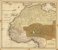
Fascinating map of the Danish Gold Coast colony in West Africa was created on the basis of surveys and measurements conducted by various Danish explorers and officials in the first part of the 19th Century.
The map provides a detailed depiction of the Danish possessions in Guinea, which were mainly concentrated along the coastline of present-day Ghana. The map captures the region after the end of the Slave Trade in 1803, when the colony redirected its efforts on establishing Cotton, Coffee and Sugar Plantations. At the time, te Danish colony consisted of several trading posts and forts established along the coast, including Christianborg, Fort Frederiksborg, and Fort Prinsensten. By 1817, almost all of the Danish posts on the Coast were abandoned, with the exception of Fort Christiansborg, which was, along with the other posts, sold to the British in 1850
The map shows the different regions of the Danish Gold Coast, including the Volta River, which was an important trade route for the Danish traders. The map also highlights the various indigenous communities and settlements in the region, as well as the topography of the area, such as hills and rivers.
The map was initially compiled by P. Thomming in 1803 and then later edited by the same person in collaboration with other explorers and officials in the subsequent years. For example, Captain Lind conducted a survey of the Volta River in 1828, while Assistant Herbst surveyed the region between Christianborg and Blegusso in 1837. Captain Vidal also contributed to the map with his measurements of land and shoreline in 1838.
Overall, the map provides a valuable historical record of the Danish colonial presence in West Africa during the 19th century.
![[West Coast Africa: Sierra Leone, Liberia and Guinea]](https://storage.googleapis.com/raremaps/img/small/40123.jpg)
![VIII. b [West Africa]](https://storage.googleapis.com/raremaps/img/small/93298.jpg)