


|
||

|

|
|

|
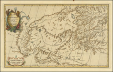
Mannevillette’s Rare Chart of the South China Sea
Rare first edition of this important and large French sea chart of South East Asia by Jean-Baptiste-Nicolas-Denis d'Après de Mannevillette, with engraving by the master engraver Guillaume Dheulland.
The map shows remarkable detail for the Philippines and the coast of southern China, extending north to the southern part of Taiwan. At the same time, the chart illustrates that significant portions of the Tonkin coastline were still thinly charted and largely unknown.
The chart is centered on the South China Sea, an area was vital for Asian and global trade. It was also known for its treacherous coasts. There are numerous sand bars, shoals, and other obstructions marked. Sounding depths abound. Still, expert navigators are needed; a note near the shore of Tunquin suggests employing a local pilot.
The chart takes in Canton and Macao, important trading entrepots for Europeans in Asia. Hong Kong, nearby, would not substantially develop until the following century. In the Philippines, Manila, on Luzon, was an anchor of the trans-Pacific galleon trade controlled by the Spanish empire.
In Formosa, or Taiwan, is a note, “the fort of Zeeland once belonged to the Dutch it was taken from them in 1661.” Fort Zeelandia was built by the Dutch East India Company from 1624 to 1634, during a period when they controlled the western part of the island. On April 30, 1661, a Ming dynasty loyalist, Koxinga, put the fort under siege. It took nine months and 1,600 Dutch lives, but the fort fell on February 1, 1662.
The title mentions “Tsiompa,” or Champa. These are the Cham polities, which occupied what it today central or southern Vietnam from the second century AD until 1832, when they were incorporated into the larger Vietnamese Empire.
To the north is “Tunquin.” Tonkin (also Tongkin, Tonquin, Tongking) refers to the northern part of what is today Vietnam. It means “eastern capital,” in reference to Hanoi. In the first millennium CE, the area for a time was under the control of China. After 938, however, it was independent and ruled by the Ngô, Đinh, Early Lê, Lý, Trần, and Hồ dynasties. Disputes with China continued, with Lê Lợi as a notable leader who fought the Ming dynasty and established himself in Hanoi in the mid-fifteenth century. By the seventeenth century, Westerners were frequent visitors to the area. They traded with the Trinh lords who were then in power. The French took the area as a protectorate from 1884 to 1945.
Canton
Canton is the most prominently labeled settlement on the chart; it is labeled with a star. The city has always been an important port city and administrative center. Ibn Battuta, the Moroccan intellectual, visited in the fourteenth century and wrote of the large shipyards at work there. Foreign visitors were banned, however, and trade restricted to formal delegations, in the late fourteenth century.
The Portuguese made their way to the city in the early sixteenth century. After a half century of tension and conflict, they were eventually allowed to trade, although they warehoused their goods at Macau instead of Canton. From the late seventeenth century, the Qing Dynasty loosened their restrictions on foreign trade somewhat, allowing a few ships each year from several Western Empires. However, Westerners were still not allowed within the Old City walls and were restricted to factories near the waterline.
From 1757, a decade after this chart was published, the Chinese employed what became known as the Canton System, which made Canton to sole port of entry for Western goods into China. A cohort of Chinese merchants, the Cohong, mediated between the Chinese government and Western traders, and they operated out of factories. The factories were destroyed by fire in 1822 and rebuilt.
Though the Western empires tolerated the Canton System, they did not like it and wanted more open access to Chinese goods, especially tea, and markets. By the late-eighteenth century, the British had accumulated a massive trade deficit as China had no interest in Western goods; they only accepted silver as payment. The East India Company began to bring opium from its Indian plantations to China instead of silver, causing a massive increase in the number of Chinese addicted to the substance.
Although the Chinese banned the import of opium, the trade continued. When China attempted to halt the trade in 1839, the British responded with force. During this conflict, the First Opium War, the British captured the factories in March 1841. In May, the Chinese mounted a counter-offensive, retaking the British Factory. Stray fireboats meant to light the Royal Navy fleet afire instead set flame to the waterfront. The British successfully countered and took control of the city on May 30, 1841.
The war ended with the Treaty of Nanking (1842), which forced the Chinese to allow British, and eventually other, traders to live in several Chinese ports unmolested. It also granted them the liberty to trade with whomever they chose. Additionally, Britain was granted a colony at Hong Kong, which led to its rapid development.
Unsurprisingly, the Chinese government was dissatisfied with the Treaty of Nanking. The British too were not entirely satisfied, as they still did not have the ideal open trade conditions they desired. In 1856, the powers went to war again.
The Second Opium War began in Canton, where Chinese marines seized a British-registered ship, the Arrow, in October 1856. The British bombarded Canton in late 1856, causing many fires, and they took the city in late 1857, with the support of the French. Eventually, Anglo-French forces advanced and burned the Summer Palaces near Beijing. The Convention of Beijing, in October 1860, saw China grant diplomatic presence in Beijing to the Russian, French, and British; the payment of an indemnity, and the cession of Kowloon to Britain. The opium trade was also declared legal and Christianity recognized. In Canton, the thirteen factories were destroyed for a final time, a destructive reminder of Canton’s prominence for the past several centuries.
The French East India Company
Mannevillette knew the waters shown here well, as he was a long-time employee of the French East India Company. Although less well-known than their English and Dutch counterparts, the FEIC was initially founded around the same time and operated in the region for over a century.
In 1604, Henry IV chartered the Compagnie des Indes Orientales, granting the Crown-operated company a fifteen-year monopoly over trade in the Far East. Later, after many setbacks and failures, the company was revamped into a joint-stock company by Jean-Baptiste Colbert in 1664. This time, the Compagnie was given a fifty-year monopoly on an area stretching from the Cape of Good Hope to the Strait of Magellan, with an intended base at Madagascar.
The Company had a rocky existence. They did not establish a colony on Madagascar, but did so on Réunion and Mauritius. They had the most success in the western Indian Ocean, with bases at Pondicherry and Changernagore. By 1719, they neared bankruptcy; an attempt to reorganize the finances of the company caused France’s economy to collapse in 1721.
The company resumed trading independently two years later. It again fell on hard times in 1769, when King Louis XV abolished it, taking over its holdings and agreeing to pay its debts. It was reconstituted once more in 1785, but this attempt foundered on the shoals of the French Revolution. On April 3, 1790, their monopoly was revoked and trade to the East Indies opened to all merchants. The company was liquidated in 1794.
Rarity
Unlike most of Mannevillette's charts, the present chart is rare on the market, having only been included in the first edition of his important atlas, Le Neptune Oriental, and replaced thereafter.
This is the first time we have offered the chart.
Jean-Baptiste Nicolas Denis d’Après de Mannevillette (1707-1780) was a French sailor and hydrographer celebrated for his excellently-rendered charts. Mannevillette was born into a maritime family and he joined his father on a French East India Company voyage to India aged only twelve. A clever boy, he returned to France to study navigation, chartmaking, and mathematics with Joseph-Nicolas De L’Isle. At nineteen, he was back at sea, working his way up the ranks of the French East India Company’s merchant fleet.
In his work with the company—he was eventually promoted captain—Mannevillette sailed to the Indian Ocean many times. En route, he was constantly gathering and correcting hydrographic knowledge. He was also skilled at using the latest navigational instruments, like the octant and later the sextant, which allowed him to make his charts especially accurate for their time. He compiled his work into his most significant publication, Le Neptune Oriental, which was commissioned by the French East India Company and first published in 1745. It was released in an expanded second edition in 1775, with posthumous expansions in 1781 and 1797.
The Neptune earned Mannevillette many accolades. The company made him Director of Charts at Lorient in 1762. In 1767, King Louis XV gave him the Order of St. Michael and named him an associate of the Royal Marine Academy.
![[Southern Philippine Islands] Carte Des Isles Philippines Dressee sur la Carte Espagnole du R.P. Murillo de Velarde 2e. Feuille](https://storage.googleapis.com/raremaps/img/small/79947.jpg)
![[ Early Industrial Philippine Logging ] Negros Philippine Lumber Co. & Insular Lumber Co. [with] The Passport of James H. Ramey](https://storage.googleapis.com/raremaps/img/small/77143.jpg)