|
||

|

|
|

|
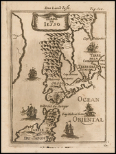
Fine Map of Japan From Skilled French Mapmaker De Vaugondy
De Vaugondy's scarce and detailed map focuses on Japan and part of Korea. It shows the archipelago in detail, with portions of the Korean Peninsula and the mysterious Terre D’Yedso.
The map includes much of the Korean Peninsula, which is just as detailed as the archipelago of Japan to the east. Japan is divided into political units, as the title indicates. The title translates to, “The empire of Japan, divided into seven principal parts, and subdivided in sixty and six kingdoms.” The divisions include provinces and daimyō, with the principal towns in each indicated.
To the west of Japan is both the Sea of Korea (Mer de Corée) and the Sea of Japan (Mer de Japon). The name of this body of water had long been disputed and is still a matter of contention today. Vaugondy erred on the side of including both names.
“Terre D’Yedso” is a reference to Jesso, a feature included on many seventeenth and eighteenth-century maps. Historically, Eso (Yeco, Jesso, Yedso, Yesso) refers to the island of Hokkaido. It varies on maps from a small island to a near-continent sized mass that stretched from Asia to Alaska.
The title is contained in an elaborate cartouche which showcases the bounty and beauty of Japan. A double scale bar is included in a simple cartouche in the lower right corner.
The map first appeared in Vaugondy’s Atlas Universal, published in 1750.
Edo Japan
The Edo period in Japan lasted from 1603 to 1868. During this time, Japan was ruled by the Tokugawa Shogunate, who was supported by 300 regional daimyō. The period was economically prosperous, politically stable, and peaceful, but this came at the expense of strict social order. It was also marked by isolation from foreigners at precisely the time Europeans were trying to access Asian markets. Also called the Tokugawa period, the Shogun was based in Edo, which today is Tokyo.
This map was drawn at a time when Japan was prosperous and strong. It was of intense interest to Europeans, even if most could only access the islands through a detailed map like this one.
Gilles Robert de Vaugondy (1688-1766) and Didier Robert de Vaugondy (1723-1786) were influential figures in the realm of 18th-century French cartography. Originating from Paris, their contributions to mapmaking were significant during an era of expansive geographical exploration.
Gilles Robert de Vaugondy entered the world of cartography not through family tradition but through personal interest and the budding opportunities of his time. Born in 1688, he worked during a time when Paris was becoming a central hub for cartographic activities. Gilles often incorporated the latest findings from explorers into his maps, making them sought-after for their contemporary relevance. His connections weren't limited to his immediate circle; he frequently interacted with other key mapmakers, staying updated on the latest techniques and findings.
His son, Didier, was born in 1723 and had the advantage of growing up surrounded by maps and globes. While his father was renowned for maps, Didier made a name for himself in the field of globemaking. His globes were some of the most precise and detailed in France, gaining recognition even among the royalty. In addition to his work in cartography and globemaking, Didier had a keen interest in education, especially after the expulsion of the Jesuits from France. He stepped in to produce geographical educational materials, fulfilling a newfound need.
The maps and globes produced by the Vaugondys remain an enduring testament to the peak of French cartography during the Enlightenment. Their works, characterized by precision and the inclusion of contemporary findings, helped to shape our understanding of the world during a transformative period in European history.
![Asie . . . 1650 [with unusual depiction of the West Coast of North America and the Island of Corey]](https://storage.googleapis.com/raremaps/img/small/102556.jpg)
![[San Francisco to British Columbia] Carta particolare dello stretto di Iezo fra l'America e I'Isola Iezo . . . D'America Carta XXXIII](https://storage.googleapis.com/raremaps/img/small/67788.jpg)