|
||

|

|
|

|
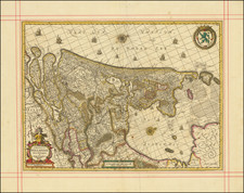
Highly decorative map of the Holy Roman Empire, published in Amsterdam in 1632.
This is the 4th of 5 states of Pieter van den Keere's map of the Holy Roman Empire of 1615.
The top border includes horseback mounted portraits of Emperor Matthias with the seven Electors. Matthias is shown twice: as emperor and as king of Bohemia and Hungary.
On three sides the map image is framed by shields with coats of arms. The coats of arms along the side borders are flanked by costumed figures.
Includes city views of the major cities of the Holy Roman Empire, including Cologne, Frankfurt, Strasbourg, Nuremberg, Prague, Augsburg, Heidelberg, Lübeck, Leipzig and Hamburg, based upon Blaeu's 1609 wall map of the Holy Roman Empire.
Jan Janssonius (also known as Johann or Jan Jansson or Janszoon) (1588-1664) was a renowned geographer and publisher of the seventeenth century, when the Dutch dominated map publishing in Europe. Born in Arnhem, Jan was first exposed to the trade via his father, who was also a bookseller and publisher. In 1612, Jan married the daughter of Jodocus Hondius, who was also a prominent mapmaker and seller. Jonssonius’ first maps date from 1616.
In the 1630s, Janssonius worked with his brother-in-law, Henricus Hondius. Their most successful venture was to reissue the Mercator-Hondius atlas. Jodocus Hondius had acquired the plates to the Mercator atlas, first published in 1595, and added 36 additional maps. After Hondius died in 1612, Henricus took over publication; Janssonius joined the venture in 1633. Eventually, the atlas was renamed the Atlas Novus and then the Atlas Major, by which time it had expanded to eleven volumes. Janssonius is also well known for his volume of English county maps, published in 1646.
Janssonius died in Amsterdam in 1664. His son-in-law, Johannes van Waesbergen, took over his business. Eventually, many of Janssonius’ plates were sold to Gerard Valck and Pieter Schenk, who added their names and continued to reissue the maps.
![Mechlinia [Mechelen]](https://storage.googleapis.com/raremaps/img/small/80595.jpg)
![[12 Folding Maps From the Library of the House of Bourbon-Orléans in Two Custom Red Morocco Boxes]](https://storage.googleapis.com/raremaps/img/small/99209.jpg)
![[ Salzburg Lungau - Tamsweg District -- Road and Trekking Map for Southern Salzburg ]](https://storage.googleapis.com/raremaps/img/small/100458.jpg)
![[ Prague ] Praga celeberrima et maxima totius Bohemiae Metropolis et Universitas florentissima ad Muldam Fl.](https://storage.googleapis.com/raremaps/img/small/67179.jpg)