


|
||

|

|
|

|
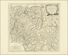
Scarce map of the Povince Sondrio in Lombardia, published by David Custodis in Frankfurt.
The map is oriented with south at the top, extending from the northern part of Lago di Como to the area around Bormeo in the Parco Nazionale dello Stelvio, incuding Tirano, Morbegno, Dubino and the Lago di Mezzola, which in former times was a part of the lake Como.
The map shows the region shortly after its conquest by Gómez Suárez de Figueroa y Córdoba, 3rd Duke of Feria, the Spanish Governor of Milan, in 1622.
Province of Sondrio
Before the Roman conquest, the region around Sondrio was inhabited by Celts (Lepontii) and Rhaetians (Camunni). During the Roman period, Sondrio was part of the Cisalpine Gaul province.
After the fall of the Western Roman Empire, the region came under the control of the Lombards and was first ruled by feudal lords from the local area. During the Middle Ages it belonged to the Kingdom of Italy. In the 14th century it fell under the rule of the Duchy of Milan due to the House of Visconti and House of Sforza.
Sondrio and Valtellina were strategically important in the politics of Europe, especially in the 16th and 17th century religious wars. The was a major cross roads through Sondrio's Spluga Pass and valleys. Upon the collapse of the Duchy of Milan, rule over Sondrio was exercised by the Swiss Canton of Graubünden. Valtellina was invaded in 1622 by the Spanish Governor of Milan as the valleys had been used to transport troops around Europe; the Spanish efforts were assisted by a 1620 revolt in Valtellina against the Swiss.
The Peace of Westphalia (1648) secured peace in the region and granted the region to the Canton of Graubünden.
![[ Piemeonte, Italy ] Pedemontanae Vicinorumque Regionum Auctore Iacobo Castaldo Descrip.](https://storage.googleapis.com/raremaps/img/small/97171.jpg)
![[ Tuscany ] Carte Du Grand-Duche De Toscane . . . 1776](https://storage.googleapis.com/raremaps/img/small/101843.jpg)